IMAGES TAKEN NEAR TO
Llanthony Road, GLOUCESTER, GL2 5HQ
Introduction
This page details the photographs taken nearby to Llanthony Road, GL2 5HQ by members of the Geograph project.
The Geograph project started in 2005 with the aim of publishing, organising and preserving representative images for every square kilometre of Great Britain, Ireland and the Isle of Man.

There are currently over 7.5m images from over14,400 individuals and you can help contribute to the project by visiting https://www.geograph.org.uk
Image Map
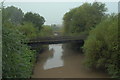
Images are licensed for reuse under creativecommons.org/licenses/by-sa/2.0
Notes
- Clicking on the map will re-center to the selected point.
- The higher the marker number, the further away the image location is from the centre of the postcode.
Image Listing (884 Images Found)
Images are licensed for reuse under creativecommons.org/licenses/by-sa/2.0
Image
Details
Distance
2
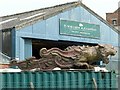
Lion figurehead at Nielsen's boatyard, Gloucester
Apparently this has featured in various films, but the origin isn't stated.
Image: © Alan Murray-Rust
Taken: 15 Apr 2019
0.05 miles
5
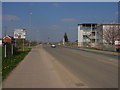
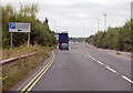
Gloucester: Llanthony Road
Llanthony Road (a part of Gloucester's bypass) and building of Gloucester College on the right hand side.
Image: © Alby
Taken: 7 Apr 2007
0.07 miles
6
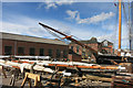
Sails and Masts
Where tall ships come for a refit.
I wonder how much of this would seem familiar to an 18th century mariner.
Image: © Des Blenkinsopp
Taken: 28 Aug 2015
0.08 miles
7
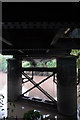
Under the docks branch viaduct, Gloucester
This view shows the steel viaduct piers, now in poor condition after 25 years or so with no maintenance. These replaced the original wooden piers when the viaduct was rebuilt in 1910.
Image: © John Winder
Taken: 13 Sep 2014
0.08 miles
8
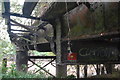
Docks branch viaduct at Glouceter showing former footbridge
Shot from directly underneath, this shows the parlous state of the old footbridge. Hidden by the steel bridge pier to the left of centre is the remains of the swinging mechanism, last operated in 1922.
Image: © John Winder
Taken: 13 Sep 2014
0.08 miles
9
Docks Branch No. 3 viaduct, Gloucester
This viaduct once carried the GWR branch from Over to Llanthony Docks. The branch was built to carry double broad gauge track in 1854 (converted in 1872 to standard gauge). This bridge, which was once a swing bridge, only ever carried single track. One thing not apparent in this view is that the track is still in place on the bridge, despite it being 25 years or so (at least) since the last train crossed.
Image: © John Winder
Taken: 13 Sep 2014
0.08 miles
10
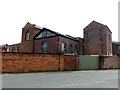
Former pumping house, Gloucester Docks
The first pump was installed in 1834 in the tall building to the left after it was found that the natural supplies to the Gloucester and Sharpness Canal were insufficient. Increasing traffic on the Canal rendered this insufficient and a second beam engine and pump were installed in the right hand building in 1855. The original engine was replaced in 1897 by a horizontal engine driving a more efficient centrifugal pump. In 1907, a further, more powerful engine and pump were installed in the new building in the centre. Electric pumps were installed in the 1940s, although steam was available on a stand-by basis until the 1960s when the extraction of water supply for Bristol was introduced. The closure of the boiler house released space which was subsequently used as workshops by British Waterways. On their closure in 1990, the buildings were taken over by the boatbuilding firm of Nielsen and Co who specialise in the repair of historic craft.
Image: © Alan Murray-Rust
Taken: 15 Apr 2019
0.08 miles