IMAGES TAKEN NEAR TO
Giles Cox, GLOUCESTER, GL2 4YL
Introduction
This page details the photographs taken nearby to Giles Cox, GL2 4YL by members of the Geograph project.
The Geograph project started in 2005 with the aim of publishing, organising and preserving representative images for every square kilometre of Great Britain, Ireland and the Isle of Man.

There are currently over 7.5m images from over14,400 individuals and you can help contribute to the project by visiting https://www.geograph.org.uk
Image Map
Images are licensed for reuse under creativecommons.org/licenses/by-sa/2.0
Notes
- Clicking on the map will re-center to the selected point.
- The higher the marker number, the further away the image location is from the centre of the postcode.
Image Listing (45 Images Found)
Images are licensed for reuse under creativecommons.org/licenses/by-sa/2.0
Image
Details
Distance
1
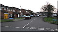
Church Drive from School Lane, Quedgeley
Church Drive leads to a large area of houses which includes a road named The Dawes near Bristol Road.
Image: © Jaggery
Taken: 22 Jan 2017
0.14 miles
2
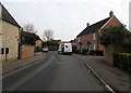
Stanbridge Way, Quedgeley
On the east side of the B4008 Bristol Road.
Image: © Jaggery
Taken: 22 Jan 2017
0.15 miles
3
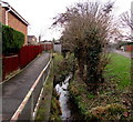
Brook between two paths, Quedgeley
On the south side of School Lane.
Image: © Jaggery
Taken: 22 Jan 2017
0.18 miles
4
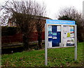
Quedgeley Parish Council noticeboard
Alongside a path on the south side of School Lane.
Formerly a village, Quedgeley is now a southern suburb of Gloucester.
Image: © Jaggery
Taken: 22 Jan 2017
0.18 miles
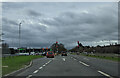

7
Give way to oncoming vehicles, School Lane, Quedgeley
A vehicle should stop at the broken white lines if another vehicle is approaching.
Image: © Jaggery
Taken: 22 Jan 2017
0.19 miles
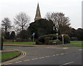
8
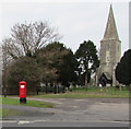
Queen Elizabeth II pillarbox and a church tower with spire, Quedgeley
Viewed across School Lane. The Parish Church of St James, Quedgeley http://www.geograph.org.uk/photo/5474370 is in the background.
Image: © Jaggery
Taken: 22 Jan 2017
0.19 miles
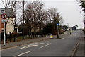
9
Junction of School Lane and St James, Quedgeley
The southern end of the road named St James viewed from School Lane.
The spire of the Parish Church of St James http://www.geograph.org.uk/photo/5474370 is in the background.
Image: © Jaggery
Taken: 22 Jan 2017
0.20 miles
10
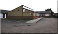
Q Club, Quedgeley
Community centre set back from the south side of School Lane.
Image: © Jaggery
Taken: 22 Jan 2017
0.20 miles