IMAGES TAKEN NEAR TO
Wharfdale Way, GLOUCESTER, GL2 4JE
Introduction
This page details the photographs taken nearby to Wharfdale Way, GL2 4JE by members of the Geograph project.
The Geograph project started in 2005 with the aim of publishing, organising and preserving representative images for every square kilometre of Great Britain, Ireland and the Isle of Man.

There are currently over 7.5m images from over14,400 individuals and you can help contribute to the project by visiting https://www.geograph.org.uk
Image Map
Images are licensed for reuse under creativecommons.org/licenses/by-sa/2.0
Notes
- Clicking on the map will re-center to the selected point.
- The higher the marker number, the further away the image location is from the centre of the postcode.
Image Listing (57 Images Found)
Images are licensed for reuse under creativecommons.org/licenses/by-sa/2.0
Image
Details
Distance
1
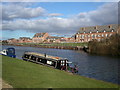
Homes on the Gloucester and Sharpness canal
Narrow boats and homes on the Gloucester and Sharpness canal close to Sellars bridge. 6kms from Gloucester docks.
Image: © Vincent Jones
Taken: 8 Feb 2006
0.02 miles
2
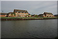
The Gloucester and Sharpness Canal
New housing overlooking the Gloucester and Sharpness Canal near the Pilot Inn at Sellars Bridge.
Image: © Philip Halling
Taken: 26 Apr 2008
0.02 miles
3
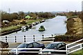
Gloucester & Sharpness Ship Canal by Sellars Bridge
Started in the late 1790's and not fully opened until 1827, the canal is much wider than most British Canals, many of which can only take narrowboats. The canal ends at Gloucester Docks, where there is a connection to the navigable section of the River Severn. Image
Image: © P L Chadwick
Taken: 27 Feb 2003
0.07 miles
4
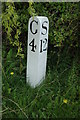
Milepost on Gloucester and Sharpness Canal
Milepost on the Gloucester and Sharpness Canal near Sellars Bridge, Gloucester is 4 miles and Sharpness 12 miles.
Image: © Philip Halling
Taken: 26 Apr 2008
0.07 miles
5
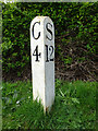
Gloucester & Sharpness Canal milestone
Gloucester 4, Sharpness 12 miles. Quedgely, Gloucester. approx 100m north of Sellar's Bridge. G&S mile peg.
Milestone Society National ID: GSC-04
Image: © Mr Red
Taken: 27 Mar 2019
0.08 miles
6
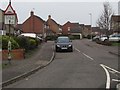
Arkendale Drive, Hardwicke
Arkendale Drive bends to the right ahead, opposite the Wharfedale Way junction.
A warning sign shows Humps for 100 yards.
Image: © Jaggery
Taken: 22 Jan 2017
0.10 miles
7
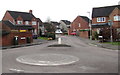
Wharfdale Way mini-roundabout in Hardwicke
At the Arkendale Drive junction.
Image: © Jaggery
Taken: 22 Jan 2017
0.10 miles
8
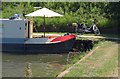
Narrowboat, Gloucester & Sharpness Canal
A relaxing spot on a hot summer's afternoon, north of Sellars Bridge.
Image: © Derek Harper
Taken: 23 Jun 2010
0.11 miles
9
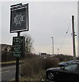
The Pilot Inn name sign, Hardwicke
On the east side of this inn. http://www.geograph.org.uk/photo/5263820
Image: © Jaggery
Taken: 22 Jan 2017
0.11 miles
10
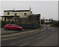
The Pilot Inn, Hardwicke
Located on the east bank of the Gloucester and Sharpness Canal. Sellars Bridge across the canal is ahead.
Image: © Jaggery
Taken: 22 Jan 2017
0.11 miles