IMAGES TAKEN NEAR TO
Spring Lane, GLOUCESTER, GL2 3SR
Introduction
This page details the photographs taken nearby to Spring Lane, GL2 3SR by members of the Geograph project.
The Geograph project started in 2005 with the aim of publishing, organising and preserving representative images for every square kilometre of Great Britain, Ireland and the Isle of Man.

There are currently over 7.5m images from over14,400 individuals and you can help contribute to the project by visiting https://www.geograph.org.uk
Image Map
Images are licensed for reuse under creativecommons.org/licenses/by-sa/2.0
Notes
- Clicking on the map will re-center to the selected point.
- The higher the marker number, the further away the image location is from the centre of the postcode.
Image Listing (23 Images Found)
Images are licensed for reuse under creativecommons.org/licenses/by-sa/2.0
Image
Details
Distance
1
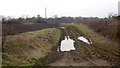
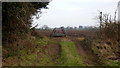
Footpath at Farley Corner. 2
Path heads generally south towards Velthouse.
Image: © Jonathan Billinger
Taken: 27 Jan 2017
0.13 miles
2
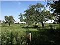
Orchard, Farley's End
Crossed by bridleway EEL/4/7 and footpath EEL/12/2, though there is no apparent means of following the path out of the orchard southwestwards.
Image: © Derek Harper
Taken: 23 Jun 2010
0.15 miles
3
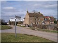
Farley's End
Hamlet around the junction of three minor roads. Looking north east.
Image: © Bob Embleton
Taken: 22 Mar 2006
0.15 miles
4
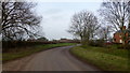
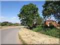
Farley Corner
Heads west towards Church Farm at Farley's End.
Image: © Jonathan Billinger
Taken: 27 Jan 2017
0.15 miles
5
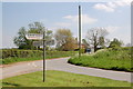
Farley Corner
The road from Kenton Green swings round towards Farley's End, approaching the junction shown in Image
Image: © Derek Harper
Taken: 23 Jun 2010
0.16 miles
6
Road junction at Farley's End
View looks south-eastwards across this junction of unclassified lanes to the south-west of Gloucester near the River Severn.
Image: © Roger Davies
Taken: 6 May 2008
0.17 miles
7
Footpath at Farley Corner. 1
The cultivator has been left in place ready for the next farming operation?
The path here heads east towards Elmore Court.
Image: © Jonathan Billinger
Taken: 27 Jan 2017
0.17 miles
8
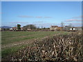
Farleys End Gloucestershire
The small village of Farleys End lies close to the river Severn. In the background to the left at a distance of 10 kilometres is May Hill and Newent Woods.
Image: © Vincent Jones
Taken: 19 Mar 2006
0.17 miles
9
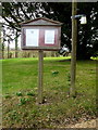
St. John's noticeboard
Service times and rusty drawing pins plus the first glimpse of the 2017 snowdrops.
Image: © Jonathan Billinger
Taken: 27 Jan 2017
0.19 miles
10
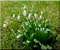
Galanthus nivalis, Common Snowdrop
Seen in context by the noticeboard for St. John's.
Image: © Jonathan Billinger
Taken: 27 Jan 2017
0.19 miles