IMAGES TAKEN NEAR TO
Boulmer Avenue Kingsway, GLOUCESTER, GL2 2FX
Introduction
This page details the photographs taken nearby to Boulmer Avenue Kingsway, GL2 2FX by members of the Geograph project.
The Geograph project started in 2005 with the aim of publishing, organising and preserving representative images for every square kilometre of Great Britain, Ireland and the Isle of Man.

There are currently over 7.5m images from over14,400 individuals and you can help contribute to the project by visiting https://www.geograph.org.uk
Image Map
Images are licensed for reuse under creativecommons.org/licenses/by-sa/2.0
Notes
- Clicking on the map will re-center to the selected point.
- The higher the marker number, the further away the image location is from the centre of the postcode.
Image Listing (10 Images Found)
Images are licensed for reuse under creativecommons.org/licenses/by-sa/2.0
Image
Details
Distance
1
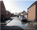
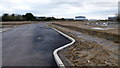
Deopham Green, Kingsway, Quedgeley, Gloucester
Recently-built houses on the south side of Wendling Road viewed in January 2019.
The road is named for Deopham Green, the former Royal Air Force station near Attleborough in Norfolk.
Houses in this area are built on the site of the former RAF Quedgeley.
Image: © Jaggery
Taken: 27 Jan 2019
0.10 miles
2
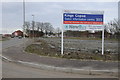
Sales board Taylor Wimpey Home
Sales board Taylor Wimpey Home on the site which was formerly RAF Quedgeley.
Image: © Philip Halling
Taken: 16 Feb 2013
0.10 miles
3
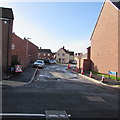
Attlebridge Way, Kingsway, Quedgeley, Gloucester
Recently-built houses viewed across Wendling Road in January 2019.
Image: © Jaggery
Taken: 27 Jan 2019
0.11 miles
4
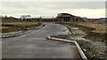
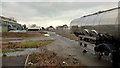
Former RAF Quedgeley, 7
This gridsquare has some industrial vestiges but is mostly filling up with housing.
Image: © Jonathan Billinger
Taken: 27 Dec 2012
0.17 miles
5
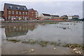
Housing development, Quedgeley
Housing development on the former RAF Quedgeley site.
Image: © Philip Halling
Taken: 16 Feb 2013
0.17 miles
6
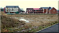
Former RAF Quedgeley, 4
This gridsquare has some industrial vestiges but is mostly filling up with housing.
Image: © Jonathan Billinger
Taken: 27 Dec 2012
0.18 miles
7
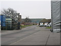
Naas Lane Industrial Area Quedgeley
These enormous buildings were once RAF Quedgeley, and were probably in existence when the 1940s map was published, but there is no trace on the early map, They are due for demolition to be converted into more modern sheds, which will raise rents, thus forcing many businesses elsewhere.
Image: © Peter Watkins
Taken: 3 Feb 2006
0.19 miles
8
Former RAF Quedgeley, 8
This gridsquare has some industrial vestiges but is mostly filling up with housing.
Looking towards the now by-passed houses on Naas Lane.
Image: © Jonathan Billinger
Taken: 27 Dec 2012
0.21 miles
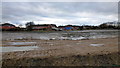
9
Former RAF Quedgeley, 5
This gridsquare has some industrial vestiges but is mostly filling up with housing.
Image: © Jonathan Billinger
Taken: 27 Dec 2012
0.24 miles
10
Former RAF Quedgeley, 1
This gridsquare has some industrial vestiges but is mostly filling up with housing.
Image: © Jonathan Billinger
Taken: 27 Dec 2012
0.25 miles