IMAGES TAKEN NEAR TO
Armscroft Crescent, GLOUCESTER, GL2 0SX
Introduction
This page details the photographs taken nearby to Armscroft Crescent, GL2 0SX by members of the Geograph project.
The Geograph project started in 2005 with the aim of publishing, organising and preserving representative images for every square kilometre of Great Britain, Ireland and the Isle of Man.

There are currently over 7.5m images from over14,400 individuals and you can help contribute to the project by visiting https://www.geograph.org.uk
Image Map
Images are licensed for reuse under creativecommons.org/licenses/by-sa/2.0
Notes
- Clicking on the map will re-center to the selected point.
- The higher the marker number, the further away the image location is from the centre of the postcode.
Image Listing (23 Images Found)
Images are licensed for reuse under creativecommons.org/licenses/by-sa/2.0
Image
Details
Distance
1
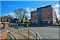
Gloucester : Barnwood - Lane
A small driveway leading to properties.
Image: © Lewis Clarke
Taken: 2 Apr 2023
0.13 miles
2
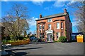
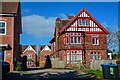
Gloucester : Barnwood - Charnwood House
A nursing home on Barnwood Road.
Image: © Lewis Clarke
Taken: 2 Apr 2023
0.15 miles
3
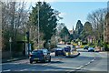
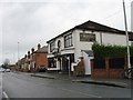
Gloucester : Barnwood Road A38
Looking along Barnwood Road.
Image: © Lewis Clarke
Taken: 2 Apr 2023
0.16 miles
4
Gloucester : Barnwood - Barnwood Road A38
Barnwood Road seen from the junction with Elmbridge Road.
Image: © Lewis Clarke
Taken: 2 Apr 2023
0.17 miles
5
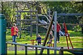
Gloucester : Friends of Elmbridge Play Area
A play area in Gloucester.
Image: © Lewis Clarke
Taken: 2 Apr 2023
0.17 miles
6
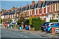
Gloucester : Barnwood - Elmbridge Road
Looking along a residential street.
Image: © Lewis Clarke
Taken: 2 Apr 2023
0.18 miles
7

Gloucester locomotive shed ? 1962
This is the former Midland Railway shed alongside the northern curve of the railway triangle to the east of Gloucester station. The site is now occupied by an aggregates company.
Image: © Alan Murray-Rust
Taken: Unknown
0.18 miles
8
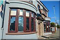
Gloucester : Barnwood - Queen's Fish & Chips
Queen's Fish & Chips on Barnwood Road.
Image: © Lewis Clarke
Taken: 2 Apr 2023
0.19 miles
10
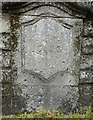
Old Boundary Marker
Municipal Boundary Marker on the northeast bridge pilaster of Branwood Bridge, Wotton Brook on the A38 Barnwood Road, Gloucester. Marks the Gloucester City boundary.
Milestone Society National ID: GL_GLOU03pb
Image: © Mr Red
Taken: 3 Apr 2019
0.21 miles