IMAGES TAKEN NEAR TO
Coronation Grove, GLOUCESTER, GL2 0SS
Introduction
This page details the photographs taken nearby to Coronation Grove, GL2 0SS by members of the Geograph project.
The Geograph project started in 2005 with the aim of publishing, organising and preserving representative images for every square kilometre of Great Britain, Ireland and the Isle of Man.

There are currently over 7.5m images from over14,400 individuals and you can help contribute to the project by visiting https://www.geograph.org.uk
Image Map
Images are licensed for reuse under creativecommons.org/licenses/by-sa/2.0
Notes
- Clicking on the map will re-center to the selected point.
- The higher the marker number, the further away the image location is from the centre of the postcode.
Image Listing (29 Images Found)
Images are licensed for reuse under creativecommons.org/licenses/by-sa/2.0
Image
Details
Distance
1
Gloucester : Barnwood - Lane
A small driveway leading to properties.
Image: © Lewis Clarke
Taken: 2 Apr 2023
0.11 miles
2
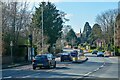
Gloucester : Barnwood Road A38
Looking along Barnwood Road.
Image: © Lewis Clarke
Taken: 2 Apr 2023
0.12 miles
3
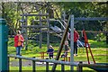
Gloucester : Friends of Elmbridge Play Area
A play area in Gloucester.
Image: © Lewis Clarke
Taken: 2 Apr 2023
0.13 miles
4
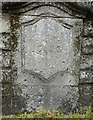
Old Boundary Marker
Municipal Boundary Marker on the northeast bridge pilaster of Branwood Bridge, Wotton Brook on the A38 Barnwood Road, Gloucester. Marks the Gloucester City boundary.
Milestone Society National ID: GL_GLOU03pb
Image: © Mr Red
Taken: 3 Apr 2019
0.16 miles
5
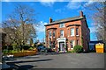
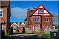
Gloucester : Barnwood - Charnwood House
A nursing home on Barnwood Road.
Image: © Lewis Clarke
Taken: 2 Apr 2023
0.17 miles
6
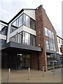
Aspen Centre
Aspen Centre, a medical centre on Horton Road in Gloucester.
Image: © Philip Halling
Taken: 13 Mar 2019
0.20 miles
7
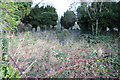
Horton Road Cemetery
Horton Road Cemetery is owned by the United Reformed Church with the majority of its burials from the Victorian period, the earliest being from 1848. Today, as can be seen here it is rather overgrown.
Image: © Philip Halling
Taken: 1 Feb 2014
0.20 miles
8
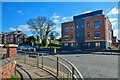
Gloucester : Barnwood - Barnwood Road A38
Barnwood Road seen from the junction with Elmbridge Road.
Image: © Lewis Clarke
Taken: 2 Apr 2023
0.20 miles
9
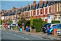
Gloucester : Barnwood - Elmbridge Road
Looking along a residential street.
Image: © Lewis Clarke
Taken: 2 Apr 2023
0.20 miles
10
![Gloucester features [4]](https://s1.geograph.org.uk/geophotos/06/58/06/6580653_ff40c106_120x120.jpg)
Gloucester features [4]
An information board giving details of Horton Road Cemetery - see Image
The cathedral city and county town of Gloucestershire, Gloucester lies on the River Severn and is linked via the Gloucester and Sharpness Canal to the river’s estuary. Founded by the Romans in AD 97, the city gained its first charter in 1155. In the Middle Ages there were a large number of monastic establishments including St Peter's Abbey founded in 679 - later Gloucester Cathedral. Until the construction of the Severn Bridge in 1966, Gloucester was the lowest road bridging point on the River Severn. The city has a long association with the aerospace business, including the Gloster Aircraft Company.
Image: © Michael Dibb
Taken: 1 Jun 2020
0.20 miles