IMAGES TAKEN NEAR TO
Sisson Road, GLOUCESTER, GL2 0RE
Introduction
This page details the photographs taken nearby to Sisson Road, GL2 0RE by members of the Geograph project.
The Geograph project started in 2005 with the aim of publishing, organising and preserving representative images for every square kilometre of Great Britain, Ireland and the Isle of Man.

There are currently over 7.5m images from over14,400 individuals and you can help contribute to the project by visiting https://www.geograph.org.uk
Image Map
Images are licensed for reuse under creativecommons.org/licenses/by-sa/2.0
Notes
- Clicking on the map will re-center to the selected point.
- The higher the marker number, the further away the image location is from the centre of the postcode.
Image Listing (5 Images Found)
Images are licensed for reuse under creativecommons.org/licenses/by-sa/2.0
Image
Details
Distance
2
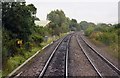
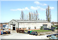
The line goes through an industrial area in Barnwood
Image: © Steve Daniels
Taken: 2 Sep 2009
0.12 miles
3
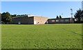
Wall's Social Club and Playing fields. Barnwood
Standing on the playing fields looking at the rear of the clubhouse
Also see image Image]
Image: © Richard Auckland
Taken: 18 Apr 2015
0.20 miles
5
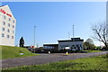
Ibis Hotel and Coronor's Court, Corinium Avenue, Barnwood
Taken from the central reservation of the dual carriageway way, this picture also shows the western approach to the recently upgraded road junction, known as Walls' Roundabout
Image: © Richard Auckland
Taken: 18 Apr 2015
0.24 miles