IMAGES TAKEN NEAR TO
Kencourt Close, GLOUCESTER, GL2 0QL
Introduction
This page details the photographs taken nearby to Kencourt Close, GL2 0QL by members of the Geograph project.
The Geograph project started in 2005 with the aim of publishing, organising and preserving representative images for every square kilometre of Great Britain, Ireland and the Isle of Man.

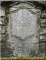
There are currently over 7.5m images from over14,400 individuals and you can help contribute to the project by visiting https://www.geograph.org.uk
Image Map
Images are licensed for reuse under creativecommons.org/licenses/by-sa/2.0
Notes
- Clicking on the map will re-center to the selected point.
- The higher the marker number, the further away the image location is from the centre of the postcode.
Image Listing (100 Images Found)
Images are licensed for reuse under creativecommons.org/licenses/by-sa/2.0
Image
Details
Distance
1
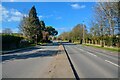
Gloucester : Estcourt Road A38
Looking along the A38 at Estcourt Road.
Image: © Lewis Clarke
Taken: 2 Apr 2023
0.03 miles
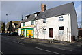
2
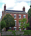
115 London Road, Gloucester
A house of c1800 with stepped voussoirs to the windows. Grade II listed.
Image: © Stephen Richards
Taken: 18 May 2015
0.05 miles
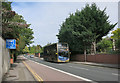
3
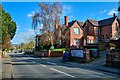
Gloucester : London Road B4063
A road heading through Gloucester.
Image: © Lewis Clarke
Taken: 2 Apr 2023
0.06 miles
4
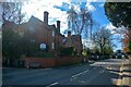
Gloucester : London Road
A road heading through Gloucester.
Image: © Lewis Clarke
Taken: 2 Apr 2023
0.06 miles
5
Old Boundary Marker
Municipal Boundary Marker on the northeast bridge pilaster of Branwood Bridge, Wotton Brook on the A38 Barnwood Road, Gloucester. Marks the Gloucester City boundary.
Milestone Society National ID: GL_GLOU03pb
Image: © Mr Red
Taken: 3 Apr 2019
0.09 miles
8
Toll House, Gloucester
May not be the original toll house, but looks the part. At the junction of London Road and Kenilworth Avenue. The Avenue was the driveway to Wotton Court (1883 maps, though Court was gone in 1903, road then adopted). The bay window and bricked-up door are obviously 20c. The apse is reminiscent of toll house architecture, clearly present in 1883, though may have been an architect's fancy to reference the site as that of a toll house. Brick built toll houses were not unknown (see Image & Image). The stone step to the adjacent dwelling is well worn, suggesting long use.
Image: © Mr Red
Taken: 13 Apr 2022
0.10 miles
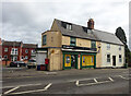
9

Postbox in London Road, Gloucester
At Wotton News shop
Image: © Schlosser67
Taken: 29 Jan 2008
0.10 miles
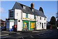
10
Wotton News and Stores and St Catherine's church
Wotton News and Stores with St Catherine's church in the background.
Image: © Philip Halling
Taken: 1 Feb 2014
0.10 miles