IMAGES TAKEN NEAR TO
Cormorant Avenue, TEWKESBURY, GL20 7RQ
Introduction
This page details the photographs taken nearby to Cormorant Avenue, GL20 7RQ by members of the Geograph project.
The Geograph project started in 2005 with the aim of publishing, organising and preserving representative images for every square kilometre of Great Britain, Ireland and the Isle of Man.

There are currently over 7.5m images from over14,400 individuals and you can help contribute to the project by visiting https://www.geograph.org.uk
Image Map
Images are licensed for reuse under creativecommons.org/licenses/by-sa/2.0
Notes
- Clicking on the map will re-center to the selected point.
- The higher the marker number, the further away the image location is from the centre of the postcode.
Image Listing (5 Images Found)
Images are licensed for reuse under creativecommons.org/licenses/by-sa/2.0
Image
Details
Distance
1
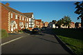
The Wheatpieces, Tewkesbury
Modern housing estate to the east of Tewkesbury, Snowdonia Road is pictured here.
Image: © Philip Halling
Taken: 11 Oct 2008
0.05 miles
2
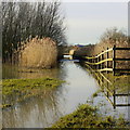
Swilgate floods, Tewkesbury
Waders would be needed for getting along this path after flooding around New Year 2014.
Image: © Jonathan Billinger
Taken: 14 Jan 2014
0.10 miles
3
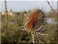
Dried-out winter teasel
Plant alongside the Tewkesbury bypass with the blurred outline of the Abbey in the flooded distance.
Image: © Jonathan Billinger
Taken: 14 Jan 2014
0.10 miles
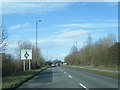
5
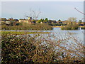
Swilgate floods
View across inundated land from Tewkesbury bypass to the Abbey.
Image: © Jonathan Billinger
Taken: 14 Jan 2014
0.13 miles