IMAGES TAKEN NEAR TO
Gloucester Road, TEWKESBURY, GL20 5SU
Introduction
This page details the photographs taken nearby to Gloucester Road, GL20 5SU by members of the Geograph project.
The Geograph project started in 2005 with the aim of publishing, organising and preserving representative images for every square kilometre of Great Britain, Ireland and the Isle of Man.

There are currently over 7.5m images from over14,400 individuals and you can help contribute to the project by visiting https://www.geograph.org.uk
Image Map
Images are licensed for reuse under creativecommons.org/licenses/by-sa/2.0
Notes
- Clicking on the map will re-center to the selected point.
- The higher the marker number, the further away the image location is from the centre of the postcode.
Image Listing (76 Images Found)
Images are licensed for reuse under creativecommons.org/licenses/by-sa/2.0
Image
Details
Distance
1
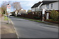
Abbots Road
Abbots Road off Gloucester Road.
Image: © Philip Halling
Taken: 22 Jan 2012
0.04 miles
2
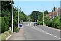
A38 Gloucester Road near Abbots Road, Tewkesbury
Image: © Roy Hughes
Taken: 25 May 2020
0.05 miles
3
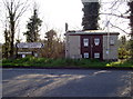
Turn left for Gloucester
The name gives it away, doesn't it? Small electrical unit opposite Abbot's Road, with the Battle Trail towards Tewkesbury.
Image: © Neil Owen
Taken: 10 Mar 2014
0.05 miles
5
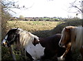
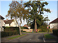
The kingdom of the horse
These two friendly fellows live in the fields alongside the Gloucester Road. It was in this area that the final battle of the War of the Roses took place, where the Yorkists removed the claim from the Lancastrians; and yes, a young Richard, Duke of Gloucester was to the fore. His history was only in the ascendancy, but Shakespeare gave him a second appraisal with reference to these essential animals.
Image: © Neil Owen
Taken: 10 Mar 2014
0.06 miles
6
Abbot's Road, Tewkesbury
One of a number of roads in this part of town which are named after figures in Tewkesbury's eventful history.
Image: © Des Blenkinsopp
Taken: 24 Aug 2019
0.08 miles
7
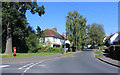
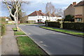
Towards Tewkesbury
Looking northwest up the Gloucester Road, opposite Lincoln Green fields. A benchmark is on the short brick pillar with the pyramidical coping stone. See Image
Image: © Neil Owen
Taken: 10 Mar 2014
0.08 miles
8
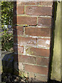
Benchmark on Gloucester Road
There aren't many marks on this stretch of the road south of Tewkesbury, but this one is opposite the Lincoln Green area - site of the battle. See Image] for a wider view northwestwards and http://www.bench-marks.org.uk/bm55597 for the entry in the Benchmark Database.
Image: © Neil Owen
Taken: 10 Mar 2014
0.08 miles
10
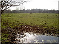
Blood makes the grass grow
Or so the old saying goes. This is part of Lincoln Green, scene of some of the bloody fighting in the Battle of Tewkesbury, 4th May, 1471. Although there are no definitive accounts of where it specifically took place, the records seem to include this part of the scenery.
The forces of the Lancastrians were heavily defeated and the ragged remains were chased up to the Bloody Meadow where many met their end.
Image: © Neil Owen
Taken: 10 Mar 2014
0.08 miles