IMAGES TAKEN NEAR TO
Longridge Lane, GLOUCESTER, GL19 4HX
Introduction
This page details the photographs taken nearby to Longridge Lane, GL19 4HX by members of the Geograph project.
The Geograph project started in 2005 with the aim of publishing, organising and preserving representative images for every square kilometre of Great Britain, Ireland and the Isle of Man.

There are currently over 7.5m images from over14,400 individuals and you can help contribute to the project by visiting https://www.geograph.org.uk
Image Map
Images are licensed for reuse under creativecommons.org/licenses/by-sa/2.0
Notes
- Clicking on the map will re-center to the selected point.
- The higher the marker number, the further away the image location is from the centre of the postcode.
Image Listing (5 Images Found)
Images are licensed for reuse under creativecommons.org/licenses/by-sa/2.0
Image
Details
Distance
1
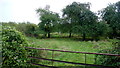
Old cider orchard, 2016
Follow-on shot from Image showing very little change.
Image: © Jonathan Billinger
Taken: 17 Oct 2016
0.02 miles
2
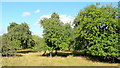
Old cider orchard
East of Longridge Lane on the edge of the Severn floodplain.
Image: © Jonathan Billinger
Taken: 21 Aug 2011
0.03 miles
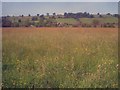
3
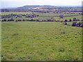
Hillside meadow at Longridge
View east across the Severn Valley to Sandhurst Hill. The Longridge lane runs behind the hedge at the bottom of this field and the river runs along the tree line beyond a further three fields.
Image: © Trevor Rickard
Taken: 4 Jun 2009
0.20 miles
4
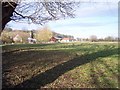
Longridge Farm
Looking north from near Longridge End
Image: © Bob Embleton
Taken: 29 Nov 2005
0.21 miles
5
Hay meadow at Longridge Farm
Looking west to the farm and a few houses at Longridge End. In these days of monoculture, nice to see a more traditional hay meadow, full of wild flowers and seeding grass. A perfect insect habitat.
Image: © Trevor Rickard
Taken: 4 Jun 2009
0.24 miles