IMAGES TAKEN NEAR TO
The Leigh, GLOUCESTER, GL19 4AA
Introduction
This page details the photographs taken nearby to GL19 4AA by members of the Geograph project.
The Geograph project started in 2005 with the aim of publishing, organising and preserving representative images for every square kilometre of Great Britain, Ireland and the Isle of Man.

There are currently over 7.5m images from over14,400 individuals and you can help contribute to the project by visiting https://www.geograph.org.uk
Image Map
Images are licensed for reuse under creativecommons.org/licenses/by-sa/2.0
Notes
- Clicking on the map will re-center to the selected point.
- The higher the marker number, the further away the image location is from the centre of the postcode.
Image Listing (18 Images Found)
Images are licensed for reuse under creativecommons.org/licenses/by-sa/2.0
Image
Details
Distance
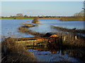
1
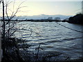
Flooded meadows near The Leigh
With the wind whipping up waves on this large stretch of floodwater by the A38 next to Fieldview Caravan Park.
Image: © Jonathan Billinger
Taken: 13 Feb 2014
0.04 miles
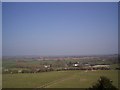
2
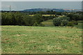
A38 approaching The Leigh
The A38 approaching The Leigh viewed from near Norton Court Farm, Prior's Norton. Bredon Hill is on the horizon.
Image: © Philip Halling
Taken: 7 Aug 2010
0.05 miles
3
Flooded Leigh Brook, 2
Using telephoto to draw the eye across the flooded Severn floodplain along the just-discernible course of the brook towards the tower of St. Catherine's church in the distance.
See also Image
Image: © Jonathan Billinger
Taken: 31 Dec 2012
0.13 miles
4
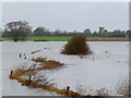
Flooded Leigh Brook, 1
View from the A38 across the inland sea that is the greater Severn floodplain.
See Image for detail view.
Image: © Jonathan Billinger
Taken: 31 Dec 2012
0.14 miles
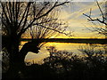
5
Flooded Leigh Brook, 2014
Not a lot different from winter floods in 2012 - see Image
The tower of St. Catherine's church in the distance.
Image: © Jonathan Billinger
Taken: 21 Feb 2014
0.14 miles
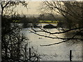
6
View from tower of St Mary's Church
View from top of St Mary's church at Prior's Norton looking in north compared to altar. The church in the distance is The Leigh
Image: © Malcolm White
Taken: 7 Apr 2007
0.15 miles
7
Two mallards on the flood
The Leigh Brook/Chelt floods taken from the A38.
Image: © Jonathan Billinger
Taken: 21 Feb 2014
0.18 miles
8
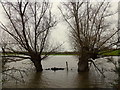
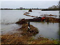
Twin willows
These trees by the A38 are submerged in the inland sea that the Severn floodplain has become.
Image: © Jonathan Billinger
Taken: 31 Dec 2012
0.18 miles
9
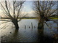
Twin Willows, 2
Following on from Image taken the previous winter.
Image: © Jonathan Billinger
Taken: 21 Feb 2014
0.18 miles
10
Chelt flood reflections, 3
Willows alongside the A38 near Inchmore Bridge.
Image: © Jonathan Billinger
Taken: 10 Jan 2014
0.20 miles