IMAGES TAKEN NEAR TO
Grange Close, GLOUCESTER, GL19 3SP
Introduction
This page details the photographs taken nearby to Grange Close, GL19 3SP by members of the Geograph project.
The Geograph project started in 2005 with the aim of publishing, organising and preserving representative images for every square kilometre of Great Britain, Ireland and the Isle of Man.

There are currently over 7.5m images from over14,400 individuals and you can help contribute to the project by visiting https://www.geograph.org.uk
Image Map
Images are licensed for reuse under creativecommons.org/licenses/by-sa/2.0
Notes
- Clicking on the map will re-center to the selected point.
- The higher the marker number, the further away the image location is from the centre of the postcode.
Image Listing (37 Images Found)
Images are licensed for reuse under creativecommons.org/licenses/by-sa/2.0
Image
Details
Distance
1
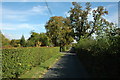
Snig's End, Corse
No through road at Snig's End, Corse. Down this road are a number of Chartist dwellings each with its own small plot of land.
Image: © Philip Halling
Taken: 24 Sep 2009
0.06 miles
3
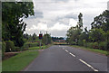
A417 entering Corse
The Malvern Hills are just visible in the distance.
Image: © Julian P Guffogg
Taken: 7 Aug 2013
0.09 miles
4
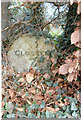
Old Milestone by the A417, Corse, Staunton parish
Carved stone post by the A417, in parish of STAUNTON (FOREST OF DEAN District), Snig's End, behind garden wire fence in beech hedge, on East side of road. Maisemore marker, erected by the Maisemore (District of Hereford & Gloucester) turnpike trust in the 19th century.
Inscription reads:-
GLOSTER
7
MILES
Milestone Society National ID: GL_GLLB07.
Image: © R Shackell
Taken: 1 Mar 2014
0.09 miles
5
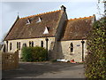
The Old School, Corse
Though rather more reminiscent of a church or chapel, I am assured by a local resident that this was indeed once the school.
Image: © Ruth Sharville
Taken: 7 Nov 2009
0.09 miles
6
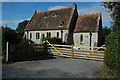
Converted school in Snig's End
A converted school building at Snig's End in Corse. Formerly it was Corse and Staunton C of E School. Earlier it was Corse C of E School, before Staunton C of E School was merged with it.
Image: © Philip Halling
Taken: 24 Sep 2009
0.10 miles
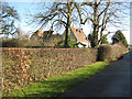
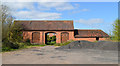
7
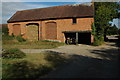
Barn at Snig's End Farm
Traditional red-brick barn complete with ventilation holes on Snig's End Farm, here it is viewed from the passing bridleway.
Image: © Philip Halling
Taken: 24 Sep 2009
0.10 miles
8
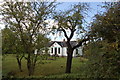
Former Chartist Land Company smallholding at Snig's End, Staunton
Image: © Roger Davies
Taken: 10 Oct 2009
0.12 miles
9
Barn, Snig's End Farm
Disused, but still in fine condition.
Image: © Philip Pankhurst
Taken: 13 Apr 2014
0.12 miles
10
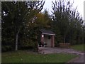
A bus shelter to relax while waiting
Two benches outside complement the shelter. The stop is served (currently) by six buses a day
Image: © David Smith
Taken: 20 Oct 2017
0.13 miles