IMAGES TAKEN NEAR TO
Hetherington Close, GLOUCESTER, GL19 3PX
Introduction
This page details the photographs taken nearby to Hetherington Close, GL19 3PX by members of the Geograph project.
The Geograph project started in 2005 with the aim of publishing, organising and preserving representative images for every square kilometre of Great Britain, Ireland and the Isle of Man.

There are currently over 7.5m images from over14,400 individuals and you can help contribute to the project by visiting https://www.geograph.org.uk
Image Map
Images are licensed for reuse under creativecommons.org/licenses/by-sa/2.0
Notes
- Clicking on the map will re-center to the selected point.
- The higher the marker number, the further away the image location is from the centre of the postcode.
Image Listing (29 Images Found)
Images are licensed for reuse under creativecommons.org/licenses/by-sa/2.0
Image
Details
Distance
2
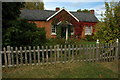
Chartist bungalow, Snig's End
In the nineteenth century the Chartists built a number of bungalows at Snig's End in Staunton, each property was set in a 2 to 4 acre plot of land.
Image: © Philip Halling
Taken: 24 Sep 2009
0.07 miles
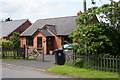
4
A Chartist's bungalow, Corse
In the nineteenth century the Chartists built a number of bungalows at Corse, each property was set in a 2 to 4 acre plot of land.
Image: © Philip Halling
Taken: 24 Sep 2009
0.09 miles
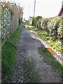
6

Former Chartist Land Company cottages at Snigs End, Staunton
The Chartist estate at Snigs End extended to over 268 acres around the village of Staunton and was built between 1847 and 1851. The 81 plot development included cottages to a common design (as seen here), a schoolhouse and a network of roads and pathways. The original settlers won their cottage with a 3 or 4 acre plot through a lottery and were provided with supplies of manure, firewood and seed. In 1848, the third National Chartist petition was taken to Parliament on a cart made at Snigs End and pulled by Snigs End horses. The "colonies" were declared illegal by a House of Commons Select Committee in 1851 and the properties sold off. Their founding light, Feargus O'Connor, died shortly after declared a lunatic.
Image: © Roger Davies
Taken: 10 Oct 2009
0.13 miles
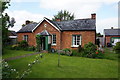
8

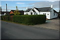
Chartist Bungalow, Ledbury Road Crescent, Staunton
Image: © Paul Shreeve
Taken: 13 Jul 2009
0.14 miles
9
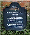
Chartist Land Company, Snigs End
A plaque on Prince Crescent, Corse. http://www.geograph.org.uk/photo/4979496
Image: © Ian S
Taken: 26 May 2016
0.14 miles
10
Chartist Land Company, Snigs End
A plaque on Prince Crescent, Corse. http://www.geograph.org.uk/photo/4979493
Image: © Ian S
Taken: 26 May 2016
0.14 miles