IMAGES TAKEN NEAR TO
Durbridge Road, GLOUCESTER, GL19 3LP
Introduction
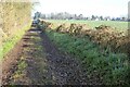
This page details the photographs taken nearby to Durbridge Road, GL19 3LP by members of the Geograph project.
The Geograph project started in 2005 with the aim of publishing, organising and preserving representative images for every square kilometre of Great Britain, Ireland and the Isle of Man.

There are currently over 7.5m images from over14,400 individuals and you can help contribute to the project by visiting https://www.geograph.org.uk
Image Map
Images are licensed for reuse under creativecommons.org/licenses/by-sa/2.0
Notes
- Clicking on the map will re-center to the selected point.
- The higher the marker number, the further away the image location is from the centre of the postcode.
Image Listing (19 Images Found)
Images are licensed for reuse under creativecommons.org/licenses/by-sa/2.0
Image
Details
Distance
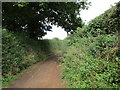
1
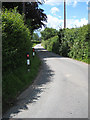
Road to Durbridge
The signpost says Durbridge; my map only shows Durbridge Farm.
Image: © Pauline E
Taken: 19 Jun 2008
0.05 miles
2
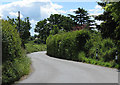
Road to Newent
From Redmarley D'Abitot. Narrow with passing places.
Image: © Pauline E
Taken: 19 Jun 2008
0.09 miles
3
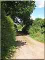
Public bridleway and Poets Path I
Poets Path I is an eight mile circular walk from Dymock taking in places associated with the Dymock Poets. (Abercrombie, Brooke, Drinkwater, Gibson, Thomas and Frost.)
Image: © Pauline E
Taken: 19 Jun 2008
0.10 miles
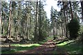
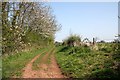
4
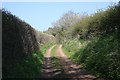
Bridleway to Cobhill Rough
Part of Poets' Path number 1 near Redmarley D'Abitot.
Image: © Bob Embleton
Taken: 18 Apr 2010
0.10 miles
5
Track to Cobhill Rough
Part of Poets' Path No. 1.
Image: © Jonathan Thacker
Taken: 16 Sep 2015
0.12 miles
6
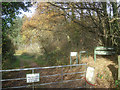
Entrance to Cobhill Wood
Apart from the public footpaths and bridleways, other marked routes in the wood are open between February and July. Managed by the Forestry Commission, but looks like the owner still retains a pheasant shoot.
Image: © Trevor Rickard
Taken: 19 Nov 2008
0.14 miles
7
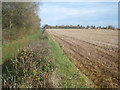
Poet's Path to Redmarley D'Abitot
Looking northwards along the track at the edge of Cobhill Rough. This is part of the Poet's Path 1, the eight-mile circular walk from Dymock. Redmarley church and houses on the right.
Image: © Trevor Rickard
Taken: 19 Nov 2008
0.14 miles
8
Path through Cobhill Rough
The waymark sign includes dates when the permissive paths in the woods are not to be used (ie in the shooting season) - a bit misleading when waymarking the right of way.
Image: © Bob Embleton
Taken: 18 Apr 2010
0.15 miles
9
Bridleway to Redmarley D'Abitot
This bridleway to Redmarley D'Abitot is part of the Poets Path No.1, a circular walk from Dymock.
Image: © Philip Halling
Taken: 13 Jan 2022
0.19 miles
10
Bridleway to Redmarley D'Abitot
Poets' Path number 1 running alongside Cobhill Rough with cherry trees in blossom.
Image: © Bob Embleton
Taken: 18 Apr 2010
0.19 miles