IMAGES TAKEN NEAR TO
Main Road, GLOUCESTER, GL19 3DZ
Introduction
This page details the photographs taken nearby to Main Road, GL19 3DZ by members of the Geograph project.
The Geograph project started in 2005 with the aim of publishing, organising and preserving representative images for every square kilometre of Great Britain, Ireland and the Isle of Man.

There are currently over 7.5m images from over14,400 individuals and you can help contribute to the project by visiting https://www.geograph.org.uk
Image Map
Images are licensed for reuse under creativecommons.org/licenses/by-sa/2.0
Notes
- Clicking on the map will re-center to the selected point.
- The higher the marker number, the further away the image location is from the centre of the postcode.
Image Listing (76 Images Found)
Images are licensed for reuse under creativecommons.org/licenses/by-sa/2.0
Image
Details
Distance
1
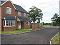
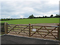
New housing at Huntley
A small development of 2 houses on the A40, currently for sale. Across the road is the recreation ground and the footpath sign, with the allotments through the 5-bar metal gate.
Image: © Pauline E
Taken: 16 Aug 2007
0.01 miles
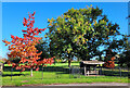
2
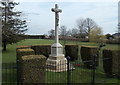
War Memorial, Huntley
Located at the southern edge of a recreation ground alongside the A40 in the small village of Huntley, Gloucestershire, the War Memorial is a stone crucifix on a hexagonal plinth on a stepped base.
Image: © Jaggery
Taken: 21 Apr 2013
0.02 miles
3
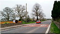
Huntley main street, 1
The A40 looking east towards Gloucester.
Image: © Jonathan Billinger
Taken: 2 Apr 2014
0.02 miles
4
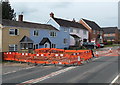
Orange barriers around A40 roadworks in Huntley
The barriers blocking the westbound carriageway of the A40
extend across the pavement, on which there is a pile of rubble.
Image: © Jaggery
Taken: 21 Apr 2013
0.02 miles
5
Huntley village stocks
Remnant of mediaeval times by the main road through the village.
Image: © Jonathan Billinger
Taken: 1 Sep 2014
0.03 miles
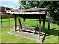
6
Village stocks, Huntley
Preserved under their shelter by the green and viewed from the A40.
Image: © Jonathan Billinger
Taken: 17 Jun 2013
0.03 miles
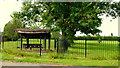
8
Huntley Playing Field
The tree to the left is a maple. The contraption to the right is the village stocks.
Image: © Jonathan Billinger
Taken: 8 Oct 2022
0.04 miles
9
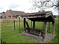
Village stocks, Huntley
Located in a fenced area on the north side of the A40 in the SW corner of a recreation ground.
Originally located alongside the main road, they were moved here the early 1970s.
It would be interesting to know when a person was last placed in these stocks as a punishment,
what misdemeanours led to the stocks, and how long a person was held in the stocks.
Image: © Jaggery
Taken: 21 Apr 2013
0.04 miles
10
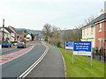
Approaching Huntley from the east
Barratt new-builds are going up to the right. Beyond the village the A40 works its way westwards to Ross-on-Wye through the wooded hills between May Hill and the Forest of Dean.
Image: © Jonathan Billinger
Taken: 27 Jan 2010
0.04 miles