IMAGES TAKEN NEAR TO
Huntley Road, GLOUCESTER, GL19 3AE
Introduction
This page details the photographs taken nearby to Huntley Road, GL19 3AE by members of the Geograph project.
The Geograph project started in 2005 with the aim of publishing, organising and preserving representative images for every square kilometre of Great Britain, Ireland and the Isle of Man.

There are currently over 7.5m images from over14,400 individuals and you can help contribute to the project by visiting https://www.geograph.org.uk
Image Map
Images are licensed for reuse under creativecommons.org/licenses/by-sa/2.0
Notes
- Clicking on the map will re-center to the selected point.
- The higher the marker number, the further away the image location is from the centre of the postcode.
Image Listing (16 Images Found)
Images are licensed for reuse under creativecommons.org/licenses/by-sa/2.0
Image
Details
Distance
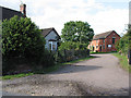
1
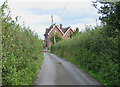
Approaching minor junction at Birdsend
Birdsend Farmhouse straight ahead.
Image: © Pauline E
Taken: 17 Aug 2008
0.04 miles
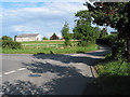
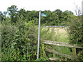
2
No through road to Rundlesshill
Old style road sign still in use. The road becomes a track then a footpath to Highnam Woods.
Image: © Pauline E
Taken: 17 Aug 2008
0.06 miles
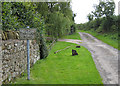
3
Heading toward Rundlesshill.
This is a no through road although it does give access to the bridleway. The road is wet and muddy.
Image: © David Robinson
Taken: 15 Nov 2008
0.07 miles
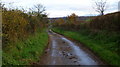
5
Footpath on a damp morning
Heading north-west and towards Poole Farm from Bulley Lane.
Image: © Jonathan Billinger
Taken: 19 Feb 2011
0.16 miles
7
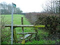
Stile and footpath
Leading to a small wood.
Image: © Pauline E
Taken: 17 Aug 2008
0.16 miles
8
Chapel under conversion
Tibberton Methodist church has closed and is now being converted into a house.
Image: © Jonathan Thacker
Taken: 22 Sep 2021
0.17 miles
9
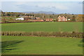
View to Tibberton
View to the village of Tibberton with the church tower in middle distance, the Malvern Hills are on the horizon.
Image: © Philip Halling
Taken: 17 Dec 2011
0.17 miles
10
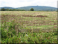
Harvested field near Birdsend
Looking west towards May Hill.
Image: © Pauline E
Taken: 17 Aug 2008
0.18 miles