IMAGES TAKEN NEAR TO
High Beech Road, RUARDEAN, GL17 9UD
Introduction
This page details the photographs taken nearby to High Beech Road, GL17 9UD by members of the Geograph project.
The Geograph project started in 2005 with the aim of publishing, organising and preserving representative images for every square kilometre of Great Britain, Ireland and the Isle of Man.

There are currently over 7.5m images from over14,400 individuals and you can help contribute to the project by visiting https://www.geograph.org.uk
Image Map
Images are licensed for reuse under creativecommons.org/licenses/by-sa/2.0
Notes
- Clicking on the map will re-center to the selected point.
- The higher the marker number, the further away the image location is from the centre of the postcode.
Image Listing (9 Images Found)
Images are licensed for reuse under creativecommons.org/licenses/by-sa/2.0
Image
Details
Distance
1
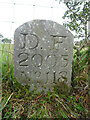
Modern Boundary Stone, The Pludds
On the North verge of Highbeech Road. One of the many replacement boundary stone delineating the periphery of the "Forest of Dean". The "Forest" is very specific because resident have "rights in common" like grazing sheep and coal mining, though you may have to be born there to classify as a "free miner".
Inscription: D. F. / 20005 / Nᴼ. 118
Milestone Society National ID: GL_DFRUAR118em
Image: © Mr Red
Taken: 27 Sep 2022
0.05 miles
2
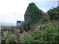
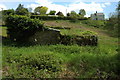
Old stone barn high above Lydbrook
An old barn or barn and pigsty combo.
Image: © Jeremy Bolwell
Taken: 5 Aug 2012
0.15 miles
3
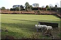
Sheep at Joy's Green
Three Texel ewes in a field at Joy's Green near Upper Lydbrook.
Image: © Philip Halling
Taken: 5 Feb 2023
0.15 miles
4
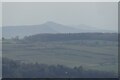
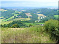
View to the Brecon Beacons
View to the Brecon Beacons from Readings on the northern edge of the Forest of Dean. There is a nice alignment here of Ysgyryd Fawr (Skirrid), Sugar Loaf and Corn Du and Pen y Fan in the Brecon Beacons.
Image: © Philip Halling
Taken: 5 Feb 2023
0.15 miles
5
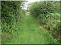
Grassy path high above Lydbrook
An old pathway for getting about up here.
Image: © Jeremy Bolwell
Taken: 5 Aug 2012
0.16 miles
6
Old stone building near Joy's Green
An old stone building, possibly an old pigsty, on the edge of the forest near Joy's Green.
Image: © Philip Halling
Taken: 10 May 2009
0.17 miles
7
Weedy field with a view
Looking north-west from near Readings.
The trench of the Wye valley is clear centre right, with Courtfield near Welsh Bicknor centre left.
The hills and farmland of Herefordshire lie beyond.
Image: © Jonathan Billinger
Taken: 3 Aug 2009
0.18 miles
8
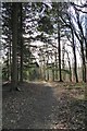
Forest path
Forest path near Joy's Green in Upper Lydbrook.
Image: © Philip Halling
Taken: 5 Feb 2023
0.22 miles
9
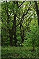
The Forest of Dean
The northern edge of the Forest of Dean near Joy's Green.
Image: © Philip Halling
Taken: 10 May 2009
0.24 miles