IMAGES TAKEN NEAR TO
School Road, LYDBROOK, GL17 9QY
Introduction
This page details the photographs taken nearby to School Road, GL17 9QY by members of the Geograph project.
The Geograph project started in 2005 with the aim of publishing, organising and preserving representative images for every square kilometre of Great Britain, Ireland and the Isle of Man.

There are currently over 7.5m images from over14,400 individuals and you can help contribute to the project by visiting https://www.geograph.org.uk
Image Map (Loading...)


Getting Data...Please wait
Leaflet Map data © OpenStreetMap
Images are licensed for reuse under creativecommons.org/licenses/by-sa/2.0
Notes
- Clicking on the map will re-center to the selected point.
- The higher the marker number, the further away the image location is from the centre of the postcode.
Image Listing (17 Images Found)
Images are licensed for reuse under creativecommons.org/licenses/by-sa/2.0
Image
Details
Distance
1
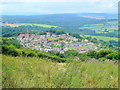
Joy's Green
A typical Forest of Dean community set on a hillside high above the Wye Valley and Lydbrook.
Viewed from the same weedy field as Image
Image: © Jonathan Billinger
Taken: 3 Aug 2009
0.03 miles
3
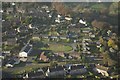
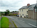
Entering Joy's Green from Ruardean
A hillside village enjoying stunning views.
Image: © Pauline E
Taken: 14 Nov 2007
0.09 miles
4
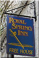
Royal Spring Inn name sign, Lower Lydbrook
Hanging from a wall bracket on the left here. http://www.geograph.org.uk/photo/4902543
Image: © Jaggery
Taken: 10 Apr 2016
0.13 miles
5
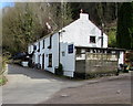
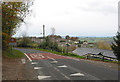
Royal Spring Inn, Lower Lydbrook
Viewed across Vention Lane from near the corner of Coppice Road.
http://www.geograph.org.uk/photo/4902557 to a closer view of the name sign on the left.
Image: © Jaggery
Taken: 10 Apr 2016
0.14 miles
6
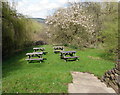
Royal Spring Inn picnic tables, Lower Lydbrook
On the west side of the inn http://www.geograph.org.uk/photo/4902543 separated from it by Vention Lane.
Image: © Jaggery
Taken: 10 Apr 2016
0.14 miles
7
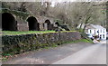
Four disused lime kilns in Lower Lydbrook
On a bank above Vention Road and the Royal Spring Inn. http://www.geograph.org.uk/photo/4902543
The kilns were used to produce lime by heating limestone at about 900 degrees Celsius. Lime was used for a variety of purposes, such as in the smelting of iron, as a fertiliser, and in making whitewash for exterior walls.
Image: © Jaggery
Taken: 10 Apr 2016
0.14 miles
8
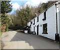
Vention Lane passes the Royal Spring Inn, Lower Lydbrook
The British History website states that Vention Lane
"apparently took its name from a coal mine known in the later 17th century as New Invention"
http://www.geograph.org.uk/photo/4902557 to a closer view of the inn name sign.
Image: © Jaggery
Taken: 10 Apr 2016
0.14 miles
9
Old Post Office, Joy's Green
On the ruardean road, looking west.
Image: © Jonathan Billinger
Taken: 3 Aug 2009
0.15 miles
10
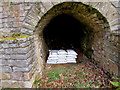
New use for a disused limekiln, Lower Lydbrook
One of these http://www.geograph.org.uk/photo/4902603 old limekilns is being used to store bags of rock salt in April 2016.
Image: © Jaggery
Taken: 10 Apr 2016
0.16 miles