IMAGES TAKEN NEAR TO
Hatton Close, LYDBROOK, GL17 9QJ
Introduction
This page details the photographs taken nearby to Hatton Close, GL17 9QJ by members of the Geograph project.
The Geograph project started in 2005 with the aim of publishing, organising and preserving representative images for every square kilometre of Great Britain, Ireland and the Isle of Man.

There are currently over 7.5m images from over14,400 individuals and you can help contribute to the project by visiting https://www.geograph.org.uk
Image Map (Loading...)


Getting Data...Please wait
Leaflet Map data © OpenStreetMap
Images are licensed for reuse under creativecommons.org/licenses/by-sa/2.0
Notes
- Clicking on the map will re-center to the selected point.
- The higher the marker number, the further away the image location is from the centre of the postcode.
Image Listing (10 Images Found)
Images are licensed for reuse under creativecommons.org/licenses/by-sa/2.0
Image
Details
Distance
1
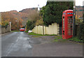
K6 phone box, Worrall Hill
Heading north towards Lydbrook and approaching the church - which is currently for sale.
Image: © Pauline E
Taken: 14 Nov 2008
0.06 miles
2
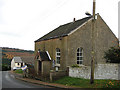
Church for sale
Worrall Hill United Reformed Church building displaying a for sale sign.
Image: © Pauline E
Taken: 14 Nov 2008
0.08 miles
3
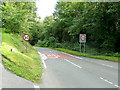
New Road/ Squires Lane junction.
Looking south, uphill, towards Coleford.
Image: © Jonathan Billinger
Taken: 6 Aug 2009
0.17 miles
4
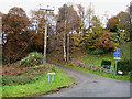
The Bourts, Worrall Hill
A steep, narrow, no-through road with no turning place. The larger scale map shows the location of Bourts Well, Bourts meaning water. The well is fed by a spring that never runs dry.
Image: © Pauline E
Taken: 14 Nov 2008
0.17 miles
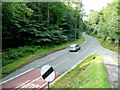
5
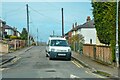
New Road, approaching Lydbrook from the south
By the junction with Squires Lane.
Image: © Jonathan Billinger
Taken: 6 Aug 2009
0.18 miles
6
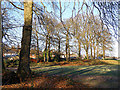
Worrall Hill football ground
Small area of land by the football pitch at Worrall Hill.
Image: © Stuart Wilding
Taken: 1 Dec 2008
0.22 miles
7
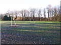
Worrall Hill football ground
View of one of the goals on a frosty morning.
Image: © Stuart Wilding
Taken: 1 Dec 2008
0.22 miles
8
West Dean : Road
A road off the A4136 to Upper Lydbrook.
Image: © Lewis Clarke
Taken: 22 Mar 2023
0.23 miles
9
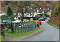
Houses at Worrall Hill
Valley Road - aptly named as the road drops steeply down into Upper Lydrook. The hillside location means the villagers have superb views across the forested valley - particularly colourful at this time of year.
Image: © Pauline E
Taken: 14 Nov 2008
0.25 miles
10
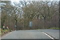
West Dean : A4136
Looking along the A4136.
Image: © Lewis Clarke
Taken: 22 Mar 2023
0.25 miles