IMAGES TAKEN NEAR TO
Camomile Green, LYDBROOK, GL17 9QA
Introduction
This page details the photographs taken nearby to Camomile Green, GL17 9QA by members of the Geograph project.
The Geograph project started in 2005 with the aim of publishing, organising and preserving representative images for every square kilometre of Great Britain, Ireland and the Isle of Man.

There are currently over 7.5m images from over14,400 individuals and you can help contribute to the project by visiting https://www.geograph.org.uk
Image Map (Loading...)


Getting Data...Please wait
Leaflet Map data © OpenStreetMap
Images are licensed for reuse under creativecommons.org/licenses/by-sa/2.0
Notes
- Clicking on the map will re-center to the selected point.
- The higher the marker number, the further away the image location is from the centre of the postcode.
Image Listing (33 Images Found)
Images are licensed for reuse under creativecommons.org/licenses/by-sa/2.0
Image
Details
Distance
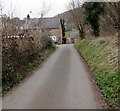
1
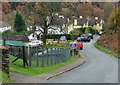
Houses at Worrall Hill
Valley Road - aptly named as the road drops steeply down into Upper Lydrook. The hillside location means the villagers have superb views across the forested valley - particularly colourful at this time of year.
Image: © Pauline E
Taken: 14 Nov 2008
0.03 miles
2
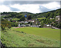
View across Upper Lydbrook from Church Road
Taken from outside the church, looking across the recreation ground.
Image: © Pauline E
Taken: 14 Sep 2007
0.06 miles
3
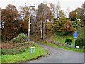
The Bourts, Worrall Hill
A steep, narrow, no-through road with no turning place. The larger scale map shows the location of Bourts Well, Bourts meaning water. The well is fed by a spring that never runs dry.
Image: © Pauline E
Taken: 14 Nov 2008
0.09 miles
4

Stepped path ascending from School Road, Lydbrook
Part of Worcester Walk.
Image: © Jaggery
Taken: 20 Mar 2016
0.14 miles
5
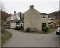
Houses at the southern end of School Road, Lydbrook
About 250 metres south of the B4234 junction.
Image: © Jaggery
Taken: 20 Mar 2016
0.15 miles
6
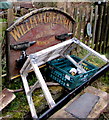
Old Forge Monmouth nameboard in Lydbrook
The board showing WILLIAM GREENMAN THE OLD FORGE MONMOUTH and a depiction of two anvils is located here http://www.geograph.org.uk/photo/5434263 in Lydbrook in March 2016.
Image: © Jaggery
Taken: 20 Mar 2016
0.17 miles
7
School Road semis, Lydbrook
Semi-detached houses near Lydbrook Primary School. http://www.geograph.org.uk/photo/5434240
A relic http://www.geograph.org.uk/photo/5434267 of the Old Forge in Monmouth is in the foreground.
Image: © Jaggery
Taken: 20 Mar 2016
0.17 miles
8
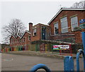
Lydbrook Primary School, Lydbrook
Viewed from the School Road perimeter fence.
Image: © Jaggery
Taken: 20 Mar 2016
0.18 miles
9
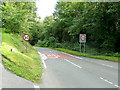
New Road, approaching Lydbrook from the south
By the junction with Squires Lane.
Image: © Jonathan Billinger
Taken: 6 Aug 2009
0.19 miles
10
North along School Road, Lydbrook
Towards Lydbrook Primary School http://www.geograph.org.uk/photo/5434240 and the B4234.
Image: © Jaggery
Taken: 20 Mar 2016
0.19 miles