IMAGES TAKEN NEAR TO
Upper Lydbrook, LYDBROOK, GL17 9LH
Introduction
This page details the photographs taken nearby to GL17 9LH by members of the Geograph project.
The Geograph project started in 2005 with the aim of publishing, organising and preserving representative images for every square kilometre of Great Britain, Ireland and the Isle of Man.

There are currently over 7.5m images from over14,400 individuals and you can help contribute to the project by visiting https://www.geograph.org.uk
Image Map (Loading...)


Getting Data...Please wait
Leaflet Map data © OpenStreetMap
Images are licensed for reuse under creativecommons.org/licenses/by-sa/2.0
Notes
- Clicking on the map will re-center to the selected point.
- The higher the marker number, the further away the image location is from the centre of the postcode.
Image Listing (12 Images Found)
Images are licensed for reuse under creativecommons.org/licenses/by-sa/2.0
Image
Details
Distance
1
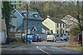
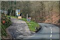
Lydbrook : B4234
Looking along the road.
Image: © Lewis Clarke
Taken: 22 Mar 2023
0.01 miles
2
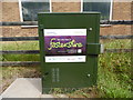
BT Green Cabinet outside Lydbrook Telephone Exchange
This photo shows the BT green cabinet outside the telephone exchange on the B4234 road in Upper Lydbrook. It mentions that you are now in Fastershire which is a project for introducing faster fibre optic broadband to homes and businesses in Gloucestershire and Herefordshire.
Image: © David Hillas
Taken: 6 Sep 2017
0.07 miles
3
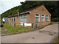
Lydbrook Telephone Exchange
Situated on the B4234 road at Upper Lydbrook, this TE has the code SSLBK and provides telephone and broadband services to 1,369 residential and 75 non-residential premises in Upper Lydbrook plus English Bicknor, Joy's Green, Lower Lydbrook, Stowfield and Welsh Bicknor nearby. BT warning notices can be seen on the fencing near the metal gate. This TE has the numbering range (01594) 860xxx, the (01594) referring to the Lydney group of nine TEs, and its postcode is GL17 9LQ.
Image: © David Hillas
Taken: 6 Sep 2017
0.07 miles
5
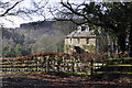
The Old Vicarage
This house is quite remote from the rest of Lydbrook.
Image: © Stuart Wilding
Taken: 4 Mar 2014
0.14 miles
6
Lydbrook : B4234
Looking along the B4234.
Image: © Lewis Clarke
Taken: 22 Mar 2023
0.15 miles
7
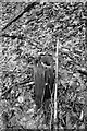
Remains of a telegraph pole
This is a pretty dull shot even for me, a veteran of posting pictures of rotting fenceposts just because they have a connection to a long-disused railway! Nevertheless, here it is ... the stump of a telegraph pole which once carried the lineside telephone cables along the route of the Severn & Wye Railway's Lydbrook branch. There are quite a few of these remaining around here, along with plenty of railway fenceposts.
Image: © John Winder
Taken: 2 Apr 2018
0.18 miles
8
Lydbrook : B4234
Looking along the B4234. A road to the left heads off to a business area.
Image: © Lewis Clarke
Taken: 22 Mar 2023
0.18 miles
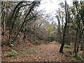
9
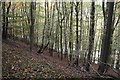
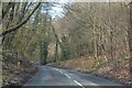
Mirystock Bottom
Beech wood hanging above the B4234.
Image: © Richard Webb
Taken: 19 Oct 2015
0.20 miles
10
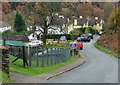
Houses at Worrall Hill
Valley Road - aptly named as the road drops steeply down into Upper Lydrook. The hillside location means the villagers have superb views across the forested valley - particularly colourful at this time of year.
Image: © Pauline E
Taken: 14 Nov 2008
0.24 miles