IMAGES TAKEN NEAR TO
High Street, DRYBROOK, GL17 9EA
Introduction
This page details the photographs taken nearby to High Street, GL17 9EA by members of the Geograph project.
The Geograph project started in 2005 with the aim of publishing, organising and preserving representative images for every square kilometre of Great Britain, Ireland and the Isle of Man.

There are currently over 7.5m images from over14,400 individuals and you can help contribute to the project by visiting https://www.geograph.org.uk
Image Map (Loading...)


Getting Data...Please wait
Leaflet Map data © OpenStreetMap
Images are licensed for reuse under creativecommons.org/licenses/by-sa/2.0
Notes
- Clicking on the map will re-center to the selected point.
- The higher the marker number, the further away the image location is from the centre of the postcode.
Image Listing (96 Images Found)
Images are licensed for reuse under creativecommons.org/licenses/by-sa/2.0
Image
Details
Distance
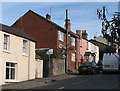
1
Cinderford bus in High Street, Drybrook
On Sunday December 11th 2016, Stagecoach bus number 25234 is on route 24A from Gloucester to Cinderford.
Image: © Jaggery
Taken: 11 Dec 2016
0.01 miles
2
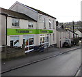
High Street Co-operative Food shop, Drybrook
Viewed in December 2016. A September 2009 Google Earth Street View shows a Nisa Local shop here.
Image: © Jaggery
Taken: 11 Dec 2016
0.01 miles
3
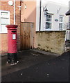
Queen Elizabeth II pillarbox, High Street, Drybrook
Located behind the black car here, http://www.geograph.org.uk/photo/5222834 outside the village post office.
Image: © Jaggery
Taken: 11 Dec 2016
0.01 miles
4
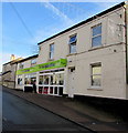
The Co-operative Food shop, High Street, Drybrook
Viewed in December 2016. A September 2009 Google Earth Street View shows a Nisa Local shop here.
Image: © Jaggery
Taken: 11 Dec 2016
0.01 miles
5
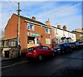
Drybrook Post Office, Drybrook
Viewed across High Street in December 2016. Drybrook has retained its post office in an era when many UK post offices have closed down, or have been replaced by a post office counter inside a shop.
Image: © Jaggery
Taken: 11 Dec 2016
0.01 miles
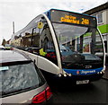
6
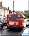
Stagecoach bus descends High Street, Drybrook
On Sunday December 11th 2016, Stagecoach bus number 25234 http://www.geograph.org.uk/photo/5236433 is on route 24A from Gloucester to Cinderford.
Image: © Jaggery
Taken: 11 Dec 2016
0.02 miles
7
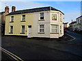
West side of the former Royal Oak pub in Drybrook
The Hawthorn Road side of the former pub on the corner of High Street, viewed in December 2016.
The pub closed down in the 1960s. http://www.geograph.org.uk/photo/5222955 to a closer view of the name sign.
A September 2009 Google Earth Street View shows Ajays hair studio on this corner.
Image: © Jaggery
Taken: 11 Dec 2016
0.02 miles
8
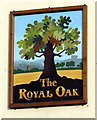
The Royal Oak name sign, Drybrook
Located here, http://www.geograph.org.uk/photo/5222952 the sign is a reminder of the Royal Oak pub which closed down in the 1960s.
Image: © Jaggery
Taken: 11 Dec 2016
0.02 miles
9
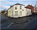
Site of a former pub on the corner of High Street and Hawthorn Road, Drybrook
Viewed in December 2016. The Royal Oak name sign http://www.geograph.org.uk/photo/5222955 is a reminder of the pub formerly on this corner,
on the north side of The Cross. The Royal Oak pub closed down in the 1960s.
Image: © Jaggery
Taken: 11 Dec 2016
0.02 miles