IMAGES TAKEN NEAR TO
Nelson Court, Morse Road, DRYBROOK, GL17 9DR
Introduction
This page details the photographs taken nearby to Nelson Court, Morse Road, GL17 9DR by members of the Geograph project.
The Geograph project started in 2005 with the aim of publishing, organising and preserving representative images for every square kilometre of Great Britain, Ireland and the Isle of Man.

There are currently over 7.5m images from over14,400 individuals and you can help contribute to the project by visiting https://www.geograph.org.uk
Image Map (Loading...)


Getting Data...Please wait
Leaflet Map data © OpenStreetMap
Images are licensed for reuse under creativecommons.org/licenses/by-sa/2.0
Notes
- Clicking on the map will re-center to the selected point.
- The higher the marker number, the further away the image location is from the centre of the postcode.
Image Listing (22 Images Found)
Images are licensed for reuse under creativecommons.org/licenses/by-sa/2.0
Image
Details
Distance
1
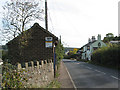
The bus stop near The Nelson Arms pub
Morse Road, near Ruardean Hill.
Image: © Pauline E
Taken: 18 Oct 2007
0.02 miles
2
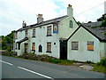
Nelson's Arms, Ruardean Hill
Now closed and partly destroyed by fire, the pub on Morse Road was originally named after a visit to the Forest of Dean by Lord Nelson himself.
Image: © Jonathan Billinger
Taken: 9 Jun 2009
0.03 miles
3
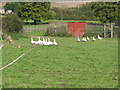
A Gaggle of Geese
Near The Nelson Arms pub in Morse Road.
Image: © Pauline E
Taken: 18 Oct 2007
0.04 miles
4
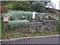
Boundary Stone & horse trough, Swish Lane
Modern horse trough (2003) and Forest of Dean boundary stone set in a feature garden with hanging evergreen plants. And aphorisms. In the Ruardean Hill/Ruardean Walk area.
Inscription: D. F. / 1832 / Nᴼ. 130 / ―
Milestone Society National ID: GL_DFDRRU130em
Image: © Mr Red
Taken: 4 Feb 2023
0.05 miles
5
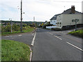
Crossroads below Ruardean Hill
The road to the left is Swish Lane; the road to the right is The Hollow which leads up to Ruardean Hill. Straight on down Morse Road from Ruardean to Drybrook.
Image: © Pauline E
Taken: 18 Oct 2007
0.05 miles
6
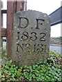
Boundary Stone, Ruardean Hill
Forest of Dean boundary stone at the apex of the junction between Batts Lane and Morse Road. Despit the date on the inscription, this is from a more recent century, probably the 20ᵗʰ.
Inscription: D. F. / 1832 / Nᴼ. 131 / ―
Milestone Society National ID: GL_DFDRYB131em
Image: © Mr Red
Taken: 4 Feb 2023
0.08 miles
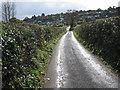
7
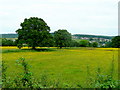
Pastoral view towards Drybrook
Looking east from Swish Lane.
Image: © Jonathan Billinger
Taken: 9 Jun 2009
0.12 miles
8
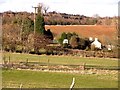
Looking towards Drybrook Quarry
The quarry is for limestone and there were rumours recently of turning it into Gloucestershire's answer to the Eden Project.
Image: © Stuart Wilding
Taken: 5 Apr 2006
0.13 miles
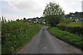
10
Sun after a shower in Swish Lane
From dull to dazzling in a few minutes. Looking south to Ruardean Hill.
Image: © Pauline E
Taken: 16 Oct 2008
0.16 miles