IMAGES TAKEN NEAR TO
Hawthorns Road, DRYBROOK, GL17 9BX
Introduction
This page details the photographs taken nearby to Hawthorns Road, GL17 9BX by members of the Geograph project.
The Geograph project started in 2005 with the aim of publishing, organising and preserving representative images for every square kilometre of Great Britain, Ireland and the Isle of Man.

There are currently over 7.5m images from over14,400 individuals and you can help contribute to the project by visiting https://www.geograph.org.uk
Image Map
Images are licensed for reuse under creativecommons.org/licenses/by-sa/2.0
Notes
- Clicking on the map will re-center to the selected point.
- The higher the marker number, the further away the image location is from the centre of the postcode.
Image Listing (98 Images Found)
Images are licensed for reuse under creativecommons.org/licenses/by-sa/2.0
Image
Details
Distance
1
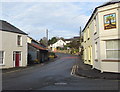
Hawthorn Road, Drybrook
Looking north from The Cross, crossroads in the centre of the village.
http://www.geograph.org.uk/photo/5222955 to a closer view of the Royal Oak name sign.
Image: © Jaggery
Taken: 11 Dec 2016
0.00 miles
2
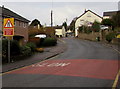
Reduce speed now, Hawthorn Road, Drybrook
Reduce speed now - the road narrows ahead.
Image: © Jaggery
Taken: 11 Dec 2016
0.01 miles
3
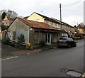
Rusty roof building in Drybrook
Former shop or other business premises viewed across Hawthorn Road in December 2016.
Image: © Jaggery
Taken: 11 Dec 2016
0.02 miles
4
Drybrook Cross electricity substation, Drybrook
Viewed across Hawthorn Road. The Western Power Distribution identifier on the wooden door of the electricity substation is 3433 DRYBROOK CROSS. A Caution notice shows the presence of SF6 (sulphur hexafluoride, an insulating gas used in high voltage systems).
Image: © Jaggery
Taken: 11 Dec 2016
0.02 miles
5
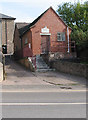
Meeting Room of Drybrook & District Male Voice Choir
Hawthorns Road, Drybrook.
Maybe it's a small choir?
The Methodist Church is behind this building.
Image: © Pauline E
Taken: 18 Oct 2007
0.02 miles
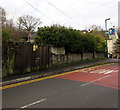
6
Gated house, Drybrook
The small fence and gate protects pedestrians from the protruding doorstep and also protects the plants; formerly the horizontal bars each side of the door supported trellis
Image: © David Smith
Taken: 3 Aug 2018
0.03 miles
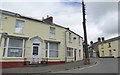
7
Site of a former pub on the corner of High Street and Hawthorn Road, Drybrook
Viewed in December 2016. The Royal Oak name sign http://www.geograph.org.uk/photo/5222955 is a reminder of the pub formerly on this corner,
on the north side of The Cross. The Royal Oak pub closed down in the 1960s.
Image: © Jaggery
Taken: 11 Dec 2016
0.03 miles
8
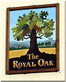
The Royal Oak name sign, Drybrook
Located here, http://www.geograph.org.uk/photo/5222952 the sign is a reminder of the Royal Oak pub which closed down in the 1960s.
Image: © Jaggery
Taken: 11 Dec 2016
0.03 miles
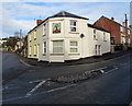
9
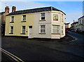
West side of the former Royal Oak pub in Drybrook
The Hawthorn Road side of the former pub on the corner of High Street, viewed in December 2016.
The pub closed down in the 1960s. http://www.geograph.org.uk/photo/5222955 to a closer view of the name sign.
A September 2009 Google Earth Street View shows Ajays hair studio on this corner.
Image: © Jaggery
Taken: 11 Dec 2016
0.03 miles
10
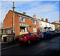
Drybrook Post Office, Drybrook
Viewed across High Street in December 2016. Drybrook has retained its post office in an era when many UK post offices have closed down, or have been replaced by a post office counter inside a shop.
Image: © Jaggery
Taken: 11 Dec 2016
0.03 miles