IMAGES TAKEN NEAR TO
Starve Beech, DRYBROOK, GL17 9BJ
Introduction
This page details the photographs taken nearby to Starve Beech, GL17 9BJ by members of the Geograph project.
The Geograph project started in 2005 with the aim of publishing, organising and preserving representative images for every square kilometre of Great Britain, Ireland and the Isle of Man.

There are currently over 7.5m images from over14,400 individuals and you can help contribute to the project by visiting https://www.geograph.org.uk
Image Map (Loading...)


Getting Data...Please wait
Leaflet Map data © OpenStreetMap
Images are licensed for reuse under creativecommons.org/licenses/by-sa/2.0
Notes
- Clicking on the map will re-center to the selected point.
- The higher the marker number, the further away the image location is from the centre of the postcode.
Image Listing (6 Images Found)
Images are licensed for reuse under creativecommons.org/licenses/by-sa/2.0
Image
Details
Distance
1
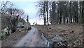
Starve Beech
A small community amidst woodland on the border of Herefordshire and Gloucestershire.
Image: © Jonathan Billinger
Taken: 8 Feb 2021
0.06 miles
2
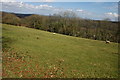
Sheep near Hope Mansell
Sheep in a field to the west of Hope Mansell.
Image: © Philip Halling
Taken: 30 Mar 2008
0.12 miles
3

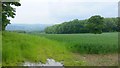
Footpath north on the edge of Perlieu Wood
A couple of limestone blocks lie poised above the valley side beside the path to Hope Mansell.
Image: © Pauline E
Taken: 21 Sep 2010
0.21 miles
4
View from Star Beech Hill, 1
Looking south-east over the late spring landscape above the Wye valley.
Lodge Grove to the right.
Image: © Jonathan Billinger
Taken: 31 May 2018
0.24 miles
5
By Cinderberry Wood
Looking south-west towards the Forest of Dean.
See also Image
Image: © Jonathan Billinger
Taken: 3 Sep 2018
0.24 miles
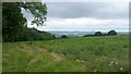
6
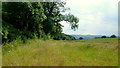
Wide headland by Cinderberry Wood
A midsummer afternoon; the main crop in the field is a bit indistinct - perhaps wheat.
Image: © Jonathan Billinger
Taken: 23 Jun 2014
0.25 miles