IMAGES TAKEN NEAR TO
Dursley Cross, LONGHOPE, GL17 0RD
Introduction
This page details the photographs taken nearby to Dursley Cross, GL17 0RD by members of the Geograph project.
The Geograph project started in 2005 with the aim of publishing, organising and preserving representative images for every square kilometre of Great Britain, Ireland and the Isle of Man.

There are currently over 7.5m images from over14,400 individuals and you can help contribute to the project by visiting https://www.geograph.org.uk
Image Map
Images are licensed for reuse under creativecommons.org/licenses/by-sa/2.0
Notes
- Clicking on the map will re-center to the selected point.
- The higher the marker number, the further away the image location is from the centre of the postcode.
Image Listing (38 Images Found)
Images are licensed for reuse under creativecommons.org/licenses/by-sa/2.0
Image
Details
Distance
1
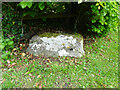
Wayside Cross, Dursley Cross, Longhope
The base of a medieval wayside cross almost in its original position. Most 1840s maps indicate the location is definitely here (contrary to local legend) and some show it in the middle of the triangle where the footpaths and bridleways meet, suggesting this was a Pilgrim Route. What is now Dursley Cross House once served as the Cross Inn. Some maps refer to the locale as "Durse Ley's Cross". Presumably on the same route to Gloucester Cathedral as the cross in Huntley (Image) about 1.6 miles to the East.
Milestone Society National ID: GLFD_LON01
Grade II listed monument see https://historicengland.org.uk/listing/the-list/list-entry/1348671
Image: © Mr Red
Taken: 12 May 2022
0.02 miles
2
Rural postbox at Dursley Cross
With the slopes of May Hill behind.
Image: © Pauline E
Taken: 14 Mar 2008
0.02 miles
3
Free range
This field has chickens, ducks, geese, sheep and lambs all getting along just fine.
Image: © Pauline E
Taken: 14 Mar 2008
0.03 miles
4

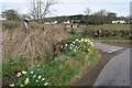
Dursley Cross, 3
Post box and one of the many narrow lanes here.
Image: © Jonathan Billinger
Taken: 28 May 2019
0.04 miles
5

Dursley Cross, 4
Showing the post box in Image in context, along side the village notice board and a long view towards May Hill.
Image: © Jonathan Billinger
Taken: 31 May 2019
0.04 miles
6
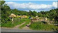
Dursley Cross, 2
A field used as a bit of a dumping ground, unfortunately.
Image: © Jonathan Billinger
Taken: 27 May 2019
0.06 miles
7

Dursley Cross, 1
Looking north towards the A40 junction and Huntley Hill beyond.
Image: © Jonathan Billinger
Taken: 23 May 2019
0.06 miles
8
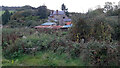
Uncultivated land, 2
At the rear of Mill House, seen here.
Image: © Jonathan Billinger
Taken: 19 Oct 2020
0.07 miles
9
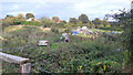
Uncultivated land, 1
Used as a dumping ground behind Mill House.
Image: © Jonathan Billinger
Taken: 8 Oct 2020
0.07 miles