IMAGES TAKEN NEAR TO
Huntley Hill, LONGHOPE, GL17 0PX
Introduction
This page details the photographs taken nearby to Huntley Hill, GL17 0PX by members of the Geograph project.
The Geograph project started in 2005 with the aim of publishing, organising and preserving representative images for every square kilometre of Great Britain, Ireland and the Isle of Man.

There are currently over 7.5m images from over14,400 individuals and you can help contribute to the project by visiting https://www.geograph.org.uk
Image Map (Loading...)


Getting Data...Please wait
Leaflet Map data © OpenStreetMap
Images are licensed for reuse under creativecommons.org/licenses/by-sa/2.0
Notes
- Clicking on the map will re-center to the selected point.
- The higher the marker number, the further away the image location is from the centre of the postcode.
Image Listing (19 Images Found)
Images are licensed for reuse under creativecommons.org/licenses/by-sa/2.0
Image
Details
Distance
1
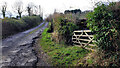
Bridleway off Hinders Lane
The rough lane ascends Huntley Hill.
Image: © Jonathan Billinger
Taken: 9 Jan 2022
0.07 miles
3
Country road to Deep Filling
Country road to Deep Filling and the A40 at Huntley.
Image: © Philip Halling
Taken: 1 Jun 2013
0.10 miles
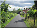
4

A4136 east to Huntley
The lane ascends the hill to give access to Hillview Corner.
Image: © Jonathan Billinger
Taken: 2 Sep 2009
0.10 miles
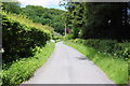
5
Hinders Lane
Looking south as the lane passes Myrtle Cottage before heading down the hill to join the A4136.
Image: © Trevor Rickard
Taken: 2 Aug 2010
0.10 miles
6
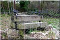
Old cider press
In a garden beside the A4136 in Little London.
Image: © David Lally
Taken: 24 Mar 2013
0.13 miles

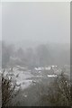
8
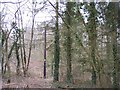
Broom Hill Wood
Looking east near the top of Broom Hill.
Image: © Bob Embleton
Taken: 23 Mar 2006
0.14 miles
9
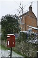
Postbox and house
Beside the A4136 at the junction with Hinders Lane.
Image: © David Lally
Taken: 23 Mar 2013
0.15 miles
10

A4136 at Little London
Looking west towards Mitcheldean and Monmouth.
Image: © Jonathan Billinger
Taken: 2 Sep 2009
0.15 miles