IMAGES TAKEN NEAR TO
School Lane, LONGHOPE, GL17 0LJ
Introduction
This page details the photographs taken nearby to School Lane, GL17 0LJ by members of the Geograph project.
The Geograph project started in 2005 with the aim of publishing, organising and preserving representative images for every square kilometre of Great Britain, Ireland and the Isle of Man.

There are currently over 7.5m images from over14,400 individuals and you can help contribute to the project by visiting https://www.geograph.org.uk
Image Map (Loading...)


Getting Data...Please wait
Leaflet Map data © OpenStreetMap
Images are licensed for reuse under creativecommons.org/licenses/by-sa/2.0
Notes
- Clicking on the map will re-center to the selected point.
- The higher the marker number, the further away the image location is from the centre of the postcode.
Image Listing (60 Images Found)
Images are licensed for reuse under creativecommons.org/licenses/by-sa/2.0
Image
Details
Distance
1
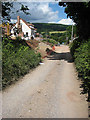
New builds in School Lane
Very nice but not exactly affordable housing. May Hill in the distance.
Image: © Pauline E
Taken: 15 Jun 2008
0.02 miles
2
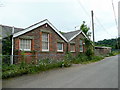
Longhope primary school 1
The old C of E school closed after a new building was established more central to the village at Hope's Brook.
Image: © Jonathan Billinger
Taken: 15 Jun 2009
0.03 miles
3
Longhope primary school 2
The building is closed and the playground silent.
See also Image
Image: © Jonathan Billinger
Taken: 15 Jun 2009
0.03 miles
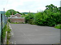
4
The Old Rectory Residential Care Home
In School Lane.
Image: © Pauline E
Taken: 15 Jun 2008
0.05 miles
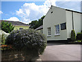
5
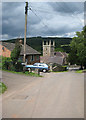
School Lane, Longhope
Looking down on All Saints Church and beyond to May Hill.
Image: © Pauline E
Taken: 15 Jun 2008
0.06 miles
6
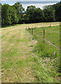
View south of School Lane, Longhope
The Gloucestershire Way LDF heads south-west here on its way via the Forest of Dean to Chepstow.
Image: © Jonathan Billinger
Taken: 15 Jun 2009
0.07 miles
7
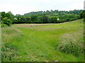
Gloucestershire Way footpath
Heading south through Longhope.
Image: © Pauline E
Taken: 15 Jun 2008
0.07 miles
8
View over All Saints' church, Longhope
Looking east from School Lane; May Hill dominates the background.
Image: © Jonathan Billinger
Taken: 15 Jun 2009
0.08 miles
9
Cottages opposite the church, Longhope
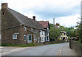
The yellow building is Court Leet, once used as the local court house - the cottage next door was the gaol.
Image: © Pauline E
Taken: 15 Jun 2008
0.08 miles
10
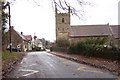
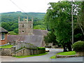
Longhope church from the south.
The village street, looking north towards the A40.
Image: © Jonathan Billinger
Taken: 4 Dec 2006
0.08 miles