IMAGES TAKEN NEAR TO
Wigpool, MITCHELDEAN, GL17 0JN
Introduction
This page details the photographs taken nearby to Wigpool, GL17 0JN by members of the Geograph project.
The Geograph project started in 2005 with the aim of publishing, organising and preserving representative images for every square kilometre of Great Britain, Ireland and the Isle of Man.

There are currently over 7.5m images from over14,400 individuals and you can help contribute to the project by visiting https://www.geograph.org.uk
Image Map (Loading...)


Getting Data...Please wait
Leaflet Map data © OpenStreetMap
Images are licensed for reuse under creativecommons.org/licenses/by-sa/2.0
Notes
- Clicking on the map will re-center to the selected point.
- The higher the marker number, the further away the image location is from the centre of the postcode.
Image Listing (18 Images Found)
Images are licensed for reuse under creativecommons.org/licenses/by-sa/2.0
Image
Details
Distance
1
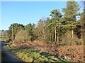
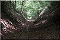
Edge of the Forest
Pretty much the last fling of the Forest of Dean in this direction. Still a lot of woodland around but much more broken up by villages and fields than in the heart of the forest.
Image: © Des Blenkinsopp
Taken: 9 Feb 2015
0.14 miles
2
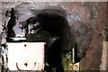
Inside the gold mine
A view inside the Forest of Dean's only goldmine, an unsuccessful venture operated at a loss between 1906 and 1908. Taken using a long exposure by poking my camera lens through a hole in the gates pictured in Des Blenkinsopp's Image
Image: © John Winder
Taken: 24 May 2020
0.15 miles
3
The Bailey Level Gold Mine
The Forest of Dean's one and only gold mine wasn't a success. Between 1906 and 1908 shares to the value of nearly 8 million pounds in today's money were issued, but the extraction of the small amount of gold actually there was not commercially viable. A certain amount of iron ore was later produced, but that probably wasn't much comfort to the original investors.
The site is now owned by the Lee Bailey Light Railway Society who are aiming to construct a narrow gauge railway along an old trackbed.
Gold mine info on https://en.wikipedia.org/wiki/Bailey_Level_Gold_Mine
Image: © Des Blenkinsopp
Taken: 12 Feb 2015
0.16 miles
4
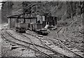
Lea Bailey Railway Siding
Along an abandoned railway track past the site of a failed gold mine, a group of enthusiasts are working on re-creating an industrial narrow gauge railway.
http://www.lblr.fod.uk
Image: © Des Blenkinsopp
Taken: 12 Feb 2015
0.16 miles
5
Entrance to 'gold mine' at Lea Bailey
Now being restored as a historic site, this mine was established in 1906 and was briefly operated in an unsuccessful attempt to extract gold. A rail track runs into the mine and along the nearby cutting.
Image: © Clint Mann
Taken: 23 May 2012
0.16 miles
6
The Lea Bailey Light Railway
A group of enthusiasts are aiming to re-create a working narrow gauge industrial railway on this long abandoned trackbed.
Part of the site includes the tunnel of a failed gold mine.
http://www.lblr.fod.uk
Image: © Des Blenkinsopp
Taken: 12 Feb 2015
0.16 miles
7
Narrow gauge rails
The rails are part of the Lea Bailey Light Railway which has been established in part on the unused route of the Mitcheldean Road & Forest of Dean Junction Railway, completed in 1882 or thereabouts by the Great Western Railway after the original promoters of the line ran out of money. The route was never opened throughout and was intended as a freight route with no passenger service, although between 1907 and 1930 the GWR operated a railmotor passenger service over the southern section of the line to Drybrook. The entire route was maintained by the GWR until, in common with many other lightly-used lines, the track was lifted in 1917 and sent to France for use on the battlefields.
Image: © John Winder
Taken: 24 May 2020
0.16 miles
8
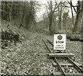
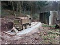
Lea Bailey Light Railway - stop here
Rickety tracks continue towards the bridge, but restoration has only got to here for the moment.
This is a project to create a restored narrow gauge line along a long disused track bed. http://www.lblr.fod.uk
Image: © Des Blenkinsopp
Taken: 12 Feb 2015
0.16 miles
9
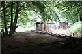
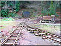
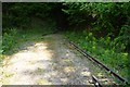
Lea Bailey Light Railway
A volunteer-run narrow gauge line, built in part on the trackbed of the old Mitcheldean Road and Forest of Dean Junction Railway. This shot shows some of the track, including the passing loop, and a storage shed.
Image: © John Winder
Taken: 24 May 2020
0.16 miles
10
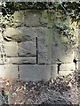
Old Bridge Marker on Hawthorns Road, Hope Mansell
Bridge Marker in the northeast parapet of a bridge on Hawthorns Road over the disused Mitcheldean Road and Forest of Dean Junction Railway. Hope Mansell parish. Inscribed G.W.R. possibly above S D C. The bridge is on a railway line built c.1874 by different contractors for the Mitcheldean Road and Forest of Dean Junction Railway Company. This company was absorbed by the GWR in 1880, who completed the line soon after. The stone is thought to mark the Great Western Railway's ownership of, or responsibility for, the bridge. The vertical groove next to the stone is unexplained but might show where a bridge weight plate, e.g. https://www.geograph.org.uk/photo/6463518, was fixed to the parapet.
Milestone Society National ID: HF_HOPEMA01br
Image: © Roadside Relics
Taken: 26 Mar 2022
0.17 miles