IMAGES TAKEN NEAR TO
Lining Wood, MITCHELDEAN, GL17 0EN
Introduction
This page details the photographs taken nearby to Lining Wood, GL17 0EN by members of the Geograph project.
The Geograph project started in 2005 with the aim of publishing, organising and preserving representative images for every square kilometre of Great Britain, Ireland and the Isle of Man.

There are currently over 7.5m images from over14,400 individuals and you can help contribute to the project by visiting https://www.geograph.org.uk
Image Map (Loading...)


Getting Data...Please wait
Leaflet Map data © OpenStreetMap
Images are licensed for reuse under creativecommons.org/licenses/by-sa/2.0
Notes
- Clicking on the map will re-center to the selected point.
- The higher the marker number, the further away the image location is from the centre of the postcode.
Image Listing (8 Images Found)
Images are licensed for reuse under creativecommons.org/licenses/by-sa/2.0
Image
Details
Distance
1
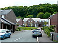
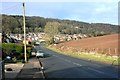
Lining Wood
The name of the recently-built housing and the woodland on the hillside beyond.
Affordable housing on the northern edge of Mitcheldean.
Image: © Jonathan Billinger
Taken: 21 May 2009
0.02 miles
2
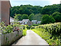
Bridleway to Lining Wood
The land to the left has been recently developed into "affordable" housing.
Image: © Jonathan Billinger
Taken: 21 May 2009
0.02 miles
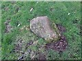
3
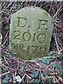
Modern Boundary Stone
On the North side of a track leading to Lining Wood, marking the boundary of the Royal Forest of Dean. Mitcheldean parish is the field on the NE side and the Forest and East Dean lie to the SW, including the top end of the nearby road also called Lining Wood.
Inscription: D. F / 1832 / Nᴼ. 179
Milestone Society National ID: GL_DFMITC179em
Image: © Mr Red
Taken: 31 Jan 2023
0.04 miles
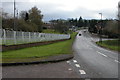
4
Carisbrooke Road, Mitcheldean
Two posh new bus shelters on the edge of the village.
Image: © Jonathan Billinger
Taken: 19 May 2022
0.14 miles
6
Bedrock, near Lining Wood, Forest of Dean
Almost certainly serving as a Boundary Marker in 1832. The evidence is from old maps showing an inflection in the boundaries where the FoD boundary then cuts across the orchard. The faint lines of the edge of the orchard can be seen on modern aerial images. This bedrock is at the distance from Lining Wood to be expected from old maps.
In terms of present day, it serves to show precisely where the boundary turns the corner.
The two parishes divided by the boundary are East Dean and Mitcheldean.
Image: © Mr Red
Taken: 31 Jan 2023
0.17 miles
7
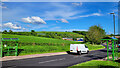
Road approaching Mitcheldean
On the left are factory units beside this road on the northern side of Mitcheldean.
Image: © Philip Halling
Taken: 3 Dec 2005
0.24 miles
8
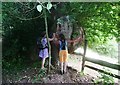
Distinctive burr on tree by path at Lining Wood
Path along eastern edge of Lining Wood passes this tree with an enormous burr growth.
Image: © Clint Mann
Taken: 20 Jul 2013
0.24 miles