IMAGES TAKEN NEAR TO
The Gorse, COLEFORD, GL16 8QF
Introduction
This page details the photographs taken nearby to The Gorse, GL16 8QF by members of the Geograph project.
The Geograph project started in 2005 with the aim of publishing, organising and preserving representative images for every square kilometre of Great Britain, Ireland and the Isle of Man.

There are currently over 7.5m images from over14,400 individuals and you can help contribute to the project by visiting https://www.geograph.org.uk
Image Map
Images are licensed for reuse under creativecommons.org/licenses/by-sa/2.0
Notes
- Clicking on the map will re-center to the selected point.
- The higher the marker number, the further away the image location is from the centre of the postcode.
Image Listing (51 Images Found)
Images are licensed for reuse under creativecommons.org/licenses/by-sa/2.0
Image
Details
Distance
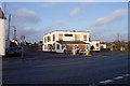
1
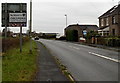
Welcome to Coleford
Alongside The Gorse near the A4136 Lower Lane junction in the south of Berry Hill.
Coleford is a small market town near the western edge of the Forest of Dean, Gloucestershire.
The town's population on the day of the 2001 Census was 8,351.
Image: © Jaggery
Taken: 23 Nov 2014
0.01 miles
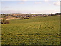
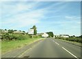
2
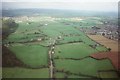
Towards Berry Hill
Coleford on the right
Image: © Peter Randall-Cook
Taken: Unknown
0.02 miles
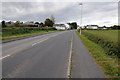
3

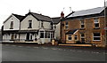
The Corner House Berry Hill
This crossroads carries the A4136 Monmouth / Gloucester road left to right.
Image: © Martin Dawes
Taken: 16 Aug 2016
0.03 miles
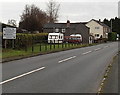
4
The Corner House, Berry Hill Pike near Coleford
The house on the right, on the corner of Grove Road and the A4136, is prosaically named The Corner House. Similar examples seen in the Coleford area today include The Bungalow and The Crescent.
Image: © Jaggery
Taken: 23 Nov 2014
0.03 miles
5
Postbox and phonebox, Berry Hill Pike
Located at the southern end of Grove Road opposite crossroads,
suggesting that the building may once have been a post office.
Image: © Jaggery
Taken: 23 Nov 2014
0.04 miles
6
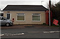
The Pike House
Sadly closed at the moment.
Image: © Jonathan Billinger
Taken: 28 Dec 2006
0.04 miles
7
View from Berry Hill Pike
This shot is taken on the border of this grid and looks out across it towards Coleford.
Image: © Stuart Wilding
Taken: 25 Feb 2006
0.04 miles
9
Directions sign on the southern approach to Berry Hill Pike
At the crossroads ahead, straight on for Symonds Yat, English Bicknor
and Christchurch, left for Staunton, right for Lydbrook.
Image: © Jaggery
Taken: 23 Nov 2014
0.05 miles
10
Approaching Berry Hill Pike
The main road between Monmouth and Gloucester A4136 crosses ahead
Image: © Martin Dawes
Taken: 16 Aug 2016
0.05 miles