IMAGES TAKEN NEAR TO
Staunton, COLEFORD, GL16 8NX
Introduction
This page details the photographs taken nearby to GL16 8NX by members of the Geograph project.
The Geograph project started in 2005 with the aim of publishing, organising and preserving representative images for every square kilometre of Great Britain, Ireland and the Isle of Man.

There are currently over 7.5m images from over14,400 individuals and you can help contribute to the project by visiting https://www.geograph.org.uk
Image Map
Images are licensed for reuse under creativecommons.org/licenses/by-sa/2.0
Notes
- Clicking on the map will re-center to the selected point.
- The higher the marker number, the further away the image location is from the centre of the postcode.
Image Listing (163 Images Found)
Images are licensed for reuse under creativecommons.org/licenses/by-sa/2.0
Image
Details
Distance
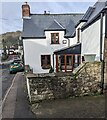
1
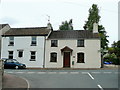
Two cottages, Staunton
Situated on the Main Street, now by-passed by the A4136 Monmouth to Gloucester Road.
Image: © Jonathan Billinger
Taken: 6 Aug 2009
0.01 miles
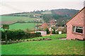
2
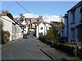
Staunton village
This road does not appear to have a name. It is the back road through the village, bypassed by the A4136.
Image: © Graham Horn
Taken: 27 Mar 2008
0.02 miles
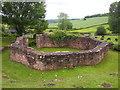
3
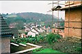
Staunton
The Elms nursing home under construction.
Image: © Peter Randall-Cook
Taken: Unknown
0.02 miles
4
Minor road from Staunton towards Newland and Redbrook
This https://www.geograph.org.uk/photo/7716965 direction sign is near the camera.
Image: © Jaggery
Taken: 25 Feb 2024
0.03 miles
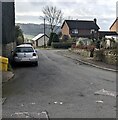
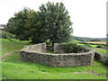
5
Staunton
View over the lower part of the village
Image: © Peter Randall-Cook
Taken: Unknown
0.03 miles
6
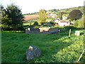
The old village pound at Staunton
Where stray farm animals were kept until their rightful owner could pay a small sum for their collection. A rare survivor and well restored.
Image: © Jeremy Bolwell
Taken: 9 Sep 2012
0.03 miles
8
The Pound, Staunton
Dates from 1828 and reconstructed in 1993.
Image: © Jonathan Thacker
Taken: 12 Sep 2018
0.03 miles
9
East side of an early 18th century house, Staunton, Gloucestershire
The rectangular tablet https://www.geograph.org.uk/photo/7716958 alongside the first floor window shows the year 1719
Image: © Jaggery
Taken: 25 Feb 2024
0.03 miles
10
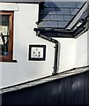
Year 1719 on the side of a Staunton house, Gloucestershire
On the wall here. https://www.geograph.org.uk/photo/7716956
Image: © Jaggery
Taken: 25 Feb 2024
0.03 miles