IMAGES TAKEN NEAR TO
Sling, COLEFORD, GL16 8JD
Introduction
This page details the photographs taken nearby to GL16 8JD by members of the Geograph project.
The Geograph project started in 2005 with the aim of publishing, organising and preserving representative images for every square kilometre of Great Britain, Ireland and the Isle of Man.

There are currently over 7.5m images from over14,400 individuals and you can help contribute to the project by visiting https://www.geograph.org.uk
Image Map
Images are licensed for reuse under creativecommons.org/licenses/by-sa/2.0
Notes
- Clicking on the map will re-center to the selected point.
- The higher the marker number, the further away the image location is from the centre of the postcode.
Image Listing (20 Images Found)
Images are licensed for reuse under creativecommons.org/licenses/by-sa/2.0
Image
Details
Distance
2
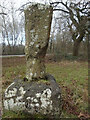
Wayside Cross, Milkwall
Base and shaft of a cross, with an OS Benchmark on the West face of the base. Near to Scar Bandstand and the B4228 just in the parish of West Dean. In a parcel of land, seemingly left fallow. No discernable inscription, some minor scratched graffiti. A similar style of cross is seen at Image
Labelled on maps variously as Gattle's/Battle's/Cattle's Cross, the "G" would appear to be the local (and definitive) version. It dates from the 17c or 18c.
Listed by Gloucestershire County Council as a monument, more information https://www.heritagegateway.org.uk/Gateway/Results_Single.aspx?uid=5072&resourceID=108
Milestone Society National ID: GLFD_WDE
Image: © Mr Red
Taken: 1 Feb 2022
0.12 miles
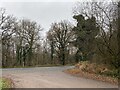
5
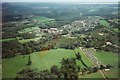
Sling
Fred Watkins Ltd is the area around the white warehouse.
Cars parked for the Clearwell summer fete
Image: © Peter Randall-Cook
Taken: Unknown
0.15 miles
6
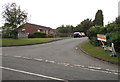
Parkend Walk, Sling
The name sign on the right shows that Parkend Walk to Laureldene.
Image: © Jaggery
Taken: 5 Jul 2015
0.17 miles
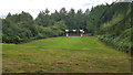
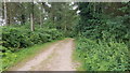
8

Road into Clearwellmeend Inclosure No 2
On the west side of the road from Ellwood to Sling in the Forest of Dean District of west Gloucestershire.
Image: © Jaggery
Taken: 5 Jul 2015
0.18 miles
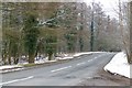
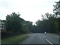
10

Patched road surface on the approach to Sling
Small potholes have been patched on the road from Ellwood
to Sling in the Forest of Dean District of west Gloucestershire.
Image: © Jaggery
Taken: 5 Jul 2015
0.21 miles