IMAGES TAKEN NEAR TO
Bircham Drive, COLEFORD, GL16 8EU
Introduction
This page details the photographs taken nearby to Bircham Drive, GL16 8EU by members of the Geograph project.
The Geograph project started in 2005 with the aim of publishing, organising and preserving representative images for every square kilometre of Great Britain, Ireland and the Isle of Man.

There are currently over 7.5m images from over14,400 individuals and you can help contribute to the project by visiting https://www.geograph.org.uk
Image Map (Loading...)


Getting Data...Please wait
Leaflet Map data © OpenStreetMap
Images are licensed for reuse under creativecommons.org/licenses/by-sa/2.0
Notes
- Clicking on the map will re-center to the selected point.
- The higher the marker number, the further away the image location is from the centre of the postcode.
Image Listing (19 Images Found)
Images are licensed for reuse under creativecommons.org/licenses/by-sa/2.0
Image
Details
Distance
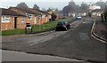
1
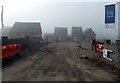
Thurstan's Rise, Coleford
David Wilson Homes house construction in progress on a foggy day in October 2014, on the SW side of Staunton Road in the NW of Coleford.
Image: © Jaggery
Taken: 12 Oct 2014
0.10 miles
2
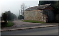
Owen Farm access road near Coleford
From the B4228 Staunton Road. The main farm buildings are 350 metres ahead.
Image: © Jaggery
Taken: 12 Oct 2014
0.10 miles
3
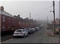
Into the fog along Albert Road, Coleford
Viewed from near the Oakfields junction on an October morning of patchy fog.
Image: © Jaggery
Taken: 12 Oct 2014
0.13 miles
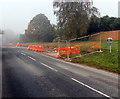
4

Start of the 30mph zone at the NW edge of Coleford
The 40mph speed limit along the B4228 Staunton Road reduces to 30mph.
A Google Earth Street View taken in September 2009 shows a Coleford
boundary sign here, near the cone on the left. It looks like it was
removed during road alteration work connected with the nearby
Thurstan's Rise housing development.
Image: © Jaggery
Taken: 12 Oct 2014
0.13 miles
5
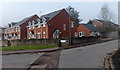
Oakfields, Coleford
Viewed from Albert Road. Oakfields leads to Meads Close. http://www.geograph.org.uk/photo/4203218
Image: © Jaggery
Taken: 12 Oct 2014
0.14 miles
6
Meads Close, Coleford
Viewed from Oakfields.
Image: © Jaggery
Taken: 12 Oct 2014
0.14 miles
7
Roadside mirror, Staunton Road, Coleford
Recently installed for the use of vehicles leaving this http://www.geograph.org.uk/photo/4206513 building site.
Image: © Jaggery
Taken: 12 Oct 2014
0.15 miles
8
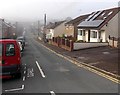
Albert Road, Coleford
Looking SW from the Staunton Road end.
Image: © Jaggery
Taken: 12 Oct 2014
0.15 miles
9
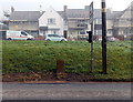
Ordnance Survey cut mark stone alongside Staunton Road, Coleford
The cut mark is a horizontal line above a vertical arrow on the stone.
The houses are in Sunnybank Road.
Image: © Jaggery
Taken: 12 Oct 2014
0.16 miles
10
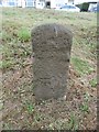
Old Milestone by the B4228, Staunton Road, Coleford
Carved stone post by the B4228, in parish of Coleford (Forest of Dean District), Staunton Road, opposite No. 45 on grassy embankment, on North-east side of road. MSTC, erected by the Monmouth Turnpike Trust in the 19th century.
The eroded inscription once read:-
(Monmouth 5)
Carved benchmark on lower front.
Milestone Society National ID: GL_MOSTCO05A.
Image: © Milestone Society
Taken: 14 Oct 2018
0.16 miles