IMAGES TAKEN NEAR TO
English Bicknor, COLEFORD, GL16 7PF
Introduction
This page details the photographs taken nearby to GL16 7PF by members of the Geograph project.
The Geograph project started in 2005 with the aim of publishing, organising and preserving representative images for every square kilometre of Great Britain, Ireland and the Isle of Man.

There are currently over 7.5m images from over14,400 individuals and you can help contribute to the project by visiting https://www.geograph.org.uk
Image Map
Images are licensed for reuse under creativecommons.org/licenses/by-sa/2.0
Notes
- Clicking on the map will re-center to the selected point.
- The higher the marker number, the further away the image location is from the centre of the postcode.
Image Listing (148 Images Found)
Images are licensed for reuse under creativecommons.org/licenses/by-sa/2.0
Image
Details
Distance
1
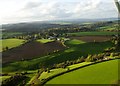
English Bicknor
Towards English Bicknor in the distance Symonds Yat and the Black mountains
Image: © Peter Randall-Cook
Taken: 31 Oct 2010
0.02 miles
3
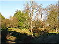
English Bicknor Castle
Today nothing much remains of English Bicknor Castle but these earthworks.
Image: © Stuart Wilding
Taken: 1 Dec 2008
0.04 miles
4

Church Hill Close, English Bicknor
One of three houses in a cul-de-sac on the west side of Church Hill.
Image: © Jaggery
Taken: 31 Jul 2016
0.04 miles
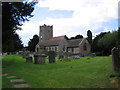
5
Lichened Gravestone, The Church of St. Mary the Virgin
Looking weathered and difficult to read.
Image: © Pauline E
Taken: 5 Oct 2007
0.05 miles
6

Road towards Eastbach at English Bicknor
Taken when walking the English Bicknor Limekilns Heritage Trail
Image: © Clint Mann
Taken: 27 Sep 2015
0.05 miles
7
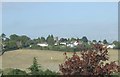
English Bicknor from across the valley
Image: © norman hyett
Taken: 19 Oct 2009
0.05 miles
8
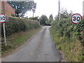
Start of the 30 zone, Church Hill, English Bicknor
On the ascent from Eastbach, the National Speed Limit on
Church Hill drops to 30mph near the corner of Church Hill Close.
Image: © Jaggery
Taken: 31 Jul 2016
0.05 miles
9

End of the 30 zone on Church Hill, English Bicknor
On the descent towards Eastbach, the 30mph speed limit on Church Hill
increases to the National Speed Limit on the corner of Church Hill Close.
Image: © Jaggery
Taken: 31 Jul 2016
0.05 miles
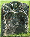
10
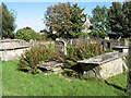
Churchyard of St. Mary the Virgin, English Bicknor
An oval churchyard with Saxon origins.
The area is the courtyard of a motte and bailey castle which once stood close by and which was destroyed in the 14th century.
Image: © Pauline E
Taken: 5 Oct 2007
0.06 miles