IMAGES TAKEN NEAR TO
Symonds Yat Rock, COLEFORD, GL16 7NZ
Introduction
This page details the photographs taken nearby to GL16 7NZ by members of the Geograph project.
The Geograph project started in 2005 with the aim of publishing, organising and preserving representative images for every square kilometre of Great Britain, Ireland and the Isle of Man.

There are currently over 7.5m images from over14,400 individuals and you can help contribute to the project by visiting https://www.geograph.org.uk
Image Map
Images are licensed for reuse under creativecommons.org/licenses/by-sa/2.0
Notes
- Clicking on the map will re-center to the selected point.
- The higher the marker number, the further away the image location is from the centre of the postcode.
Image Listing (127 Images Found)
Images are licensed for reuse under creativecommons.org/licenses/by-sa/2.0
Image
Details
Distance
2
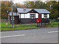
The Old Post Office near Symonds Yat Rock
There are two red postboxes in view. The one on the left, on the road side of the fence, is a Queen Elizabeth II postbox. The King George V box on the house side of the fence is for deliveries of mail for The Old Post Office only.
Image: © Jaggery
Taken: 3 Aug 2014
0.00 miles
3
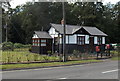
The Old Post Office, Symonds Yat (East)
Image: © Chris Allen
Taken: 30 Oct 2021
0.00 miles
4
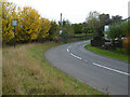
Road at Symonds Yat Rock
The sign on the left proclaims Symonds Yat Rock with a representation of the view over the River Wye.
Image: © Chris Allen
Taken: 30 Oct 2021
0.02 miles
5
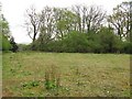
Field with thin soil
A former car park? On the plateau at Symond's Yat. Big drop beyond the trees.
Image: © Richard Webb
Taken: 3 May 2010
0.03 miles
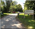
6
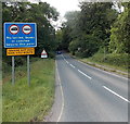
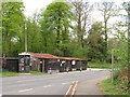
Ignore satnav near Symonds Yat Rock
Signs show no lorries, buses or coaches beyond this point (near the entrance to Symonds Yat Rock). The triangular sign in the background shows a 1 in 5 descent ahead - use low gear for ½ mile.
Image: © Jaggery
Taken: 3 Aug 2014
0.07 miles
7
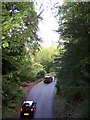
B4432 near Yat Rock, Symonds Yat
The narrow B4432 takes traffic up to (and down from) the Yat Rock Viewpoint area ... this picture is taken from the Wooden Bridge, see ... Image
Image: © Terry Robinson
Taken: 12 Sep 2010
0.08 miles
8
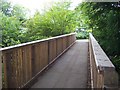
Bridge to Yat Rock, near Symonds Yat
This bridge takes the path, from the 'Visitor Centre', over the B4432 and on to the Yat Rock Viewpoint.
Image: © Terry Robinson
Taken: 12 Sep 2010
0.08 miles
9
Entrance road to Symonds Yat Rock
Symonds Yat Rock is a Forestry Commission managed site overlooking the River Wye,
well-known for its views which include nearby cliffs where peregrine falcons nest.
Image: © Jaggery
Taken: 3 Aug 2014
0.08 miles
10
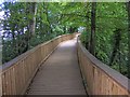
Wooden Trail to Yat Rock Viewpoint, near Symonds Yat
Image: © Terry Robinson
Taken: 12 Sep 2010
0.09 miles