IMAGES TAKEN NEAR TO
Wood Edge Road, COLEFORD, GL16 7LF
Introduction
This page details the photographs taken nearby to Wood Edge Road, GL16 7LF by members of the Geograph project.
The Geograph project started in 2005 with the aim of publishing, organising and preserving representative images for every square kilometre of Great Britain, Ireland and the Isle of Man.

There are currently over 7.5m images from over14,400 individuals and you can help contribute to the project by visiting https://www.geograph.org.uk
Image Map
Images are licensed for reuse under creativecommons.org/licenses/by-sa/2.0
Notes
- Clicking on the map will re-center to the selected point.
- The higher the marker number, the further away the image location is from the centre of the postcode.
Image Listing (45 Images Found)
Images are licensed for reuse under creativecommons.org/licenses/by-sa/2.0
Image
Details
Distance
1
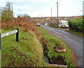
Wood Edge Road, Lower Milkwall
Viewed from Ellwood Road. In the foreground, there is a concrete base on the grass containing
what looks like a metal support for a (railway) rail, to secure it to a sleeper.
Its significance, if any, is unclear. Old maps show that Milkwall railway station was formerly located about 300 metres north of this point. Passenger services at the station ceased in 1929.
Image: © Jaggery
Taken: 12 Dec 2011
0.02 miles
2
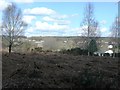
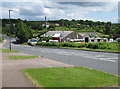
Forest of Dean landscape
Not all of the forest is pretty woodland. Much is a very bitty landscape borne out of the coal mining legacy. Here is a rough heath between disparate small former mining villages.
Image: © Graham Horn
Taken: 27 Mar 2008
0.04 miles
4
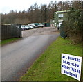
Dead slow pedestrians crossing, Lower Milkwall
Located at the entrance to The New Buildings. http://www.geograph.org.uk/photo/3260562
In the absence of punctuation, one possible though unlikely interpretation is
All drivers: dead slow pedestrians crossing.
Presumably the message is intended to be
All drivers dead slow : pedestrians crossing.
Image: © Jaggery
Taken: 12 Dec 2011
0.12 miles
5
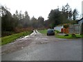
Track into the forest, Lower Milkwall
On the south side of Ellwood Road, a track heads into the Forest of Dean.
The road bends to the right towards business units in The New Buildings.
Image: © Jaggery
Taken: 12 Dec 2011
0.13 miles
6
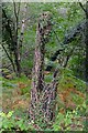
Remains of railway fence
This fence post - resourcefully made of half an old railway sleeper - has seen better days! Alongside the old Coleford branch line near the site of Robert Mushet's Titanic steelworks.
Image: © John Winder
Taken: 5 Oct 2019
0.14 miles
7
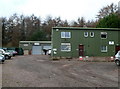
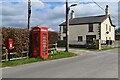
The New Buildings, Lower Milkwall
The New Buildings are a group of 4 business units located
between Ellwood Road and Clearwell Meend in the Forest of Dean.
Image: © Jaggery
Taken: 12 Dec 2011
0.15 miles
8
Station Road Garage, Milkwall
Premises of Brian J.Aston coach and bus hire.
Image: © Jaggery
Taken: 12 Dec 2011
0.16 miles
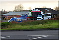
9
KWT Coaches, Milkwall
Coaches for hire in Station Road.
Image: © Pauline E
Taken: 12 Jun 2008
0.16 miles
10
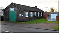
Milkwall Village Hall
The 20 metre long wooden building is on the south side of Station Road. It was originally an army hut dating from 1926. The building contains a hall with a capacity of 70 and one meeting room.
Image: © Jaggery
Taken: 12 Dec 2011
0.16 miles