IMAGES TAKEN NEAR TO
Palmers Flat, COLEFORD, GL16 7HU
Introduction
This page details the photographs taken nearby to Palmers Flat, GL16 7HU by members of the Geograph project.
The Geograph project started in 2005 with the aim of publishing, organising and preserving representative images for every square kilometre of Great Britain, Ireland and the Isle of Man.

There are currently over 7.5m images from over14,400 individuals and you can help contribute to the project by visiting https://www.geograph.org.uk
Image Map (Loading...)


Getting Data...Please wait
Leaflet Map data © OpenStreetMap
Images are licensed for reuse under creativecommons.org/licenses/by-sa/2.0
Notes
- Clicking on the map will re-center to the selected point.
- The higher the marker number, the further away the image location is from the centre of the postcode.
Image Listing (12 Images Found)
Images are licensed for reuse under creativecommons.org/licenses/by-sa/2.0
Image
Details
Distance
1
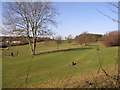
Forest of Dean Golf Club
Looking towards the North West.
Image: © Stuart Wilding
Taken: 10 Feb 2006
0.00 miles
2
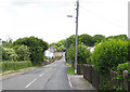
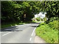
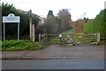
Palmer's Flat
The road to Coalway from Milkwall passes through Palmer's Flat on the edge of the Forest of Dean.
Image: © Pauline E
Taken: 12 Jun 2008
0.05 miles
3
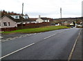
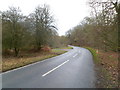
Palmer's Flat south of Coalway
The road from Coalway to Milkwall passes through Palmer's Flat.
Image: © Jaggery
Taken: 11 Dec 2011
0.08 miles
4
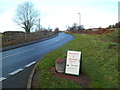
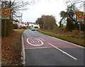
Station Road heads north away from Milkwall towards Palmers Flat
Viewed from the corner of the lane http://www.geograph.org.uk/photo/3260853 to Gorsty Knoll,
along which a notice points towards used furniture and household goods.
Image: © Jaggery
Taken: 12 Dec 2011
0.15 miles
6
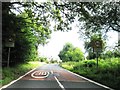
Southern junction of Parkend Road and Parkend Walk, Coalway
Viewed across Parkend Road. The roads which diverged about 220 metres behind
the camera meet again ahead on the left. This view is of the western edge of the Forest of Dean.
Image: © Jaggery
Taken: 11 Dec 2011
0.19 miles
7
Southern boundary of Coalway
Parkend Road reaches the boundary of Coalway, a village
contiguous with Coleford at the western edge of the Forest of Dean.
Image: © Jaggery
Taken: 11 Dec 2011
0.21 miles
8

Old Milestone by Parkend Road, Coalway, Forest of Dean
Carved stone post by the UC road, in parish of WEST DEAN (FOREST OF DEAN District), close to 'Coalway' road sign, on grass verge, on West side of road. Passage stone erected by the Forest of Dean turnpike trust in the 19th century.
Inscription reads:-
Coleford
1 Mile
Purton
Carved benchmark on front.
Milestone Society National ID: GL_COPU01.
Image: © K Walker & R Harvey
Taken: 10 Feb 2003
0.21 miles
10
Milkwall side of the cycle track to Coleford
Viewed across Station Road from near the site of the former Milkwall railway station. Because they mostly have gentle, if any, inclines, the routes of dismantled railways are a good and frequently used choice for cycle tracks, as here.
Image: © Jaggery
Taken: 12 Dec 2011
0.23 miles