IMAGES TAKEN NEAR TO
Clay Road, COLEFORD, GL16 7GB
Introduction
This page details the photographs taken nearby to Clay Road, GL16 7GB by members of the Geograph project.
The Geograph project started in 2005 with the aim of publishing, organising and preserving representative images for every square kilometre of Great Britain, Ireland and the Isle of Man.

There are currently over 7.5m images from over14,400 individuals and you can help contribute to the project by visiting https://www.geograph.org.uk
Image Map
Images are licensed for reuse under creativecommons.org/licenses/by-sa/2.0
Notes
- Clicking on the map will re-center to the selected point.
- The higher the marker number, the further away the image location is from the centre of the postcode.
Image Listing (21 Images Found)
Images are licensed for reuse under creativecommons.org/licenses/by-sa/2.0
Image
Details
Distance
1
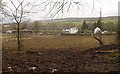
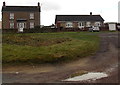
Houses at Joyford
This area at the edge of the forest was probably settled in the C18. View from a narrow strip of access land that continues the line of Clay Lane and probably follows its former course down to Joyford.
Image: © Derek Harper
Taken: 2 Feb 2010
0.09 miles
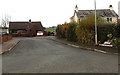
2
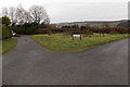
Grass triangle, Nine Wells Road, Berry Hill
Left for Rosebay Meadow and The Brambles.
Image: © Jaggery
Taken: 23 Nov 2014
0.12 miles
3
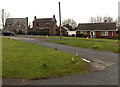
Houses on the north side of Nine Wells Road, Berry Hill
Image: © Jaggery
Taken: 23 Nov 2014
0.13 miles
4
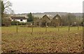
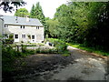
Ruined building at Joyford
This ruined farmhouse is seen, like Image, from access land below Clay Lane.
Image: © Derek Harper
Taken: 2 Feb 2010
0.15 miles
5
Forest View and The New Bungalow, Berry Hill
Nine Wells Road houses.
Image: © Jaggery
Taken: 23 Nov 2014
0.16 miles
6
House at Ninewell Bottom
On the edge of the main block of the Forest of Dean.
Image: © Jonathan Billinger
Taken: 6 Aug 2009
0.16 miles
7
Corner of Nine Wells Road and Nine Wells Close, Berry Hill
The Nine Wells Close name sign on the right is at pavement level.
Image: © Jaggery
Taken: 23 Nov 2014
0.19 miles
8
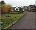
Muddles, Joyford Hill
Set back from the edge of Joyford Hill. The name sign is in the lower left corner.
Image: © Jaggery
Taken: 23 Nov 2014
0.20 miles
9
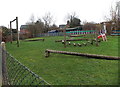
Junior level assault course, Berry Hill Primary School, Coleford
Low-level equipment and a small slide designed for primary school children.
Viewed across a Nine Wells Road fence, on the north side of the school. http://www.geograph.org.uk/photo/4256578
Image: © Jaggery
Taken: 23 Nov 2014
0.21 miles
10
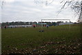
Sunday Football match at Five Acres
This football pitch is on the site of a college and leisure centre at Five Acres.
Image: © Philip Halling
Taken: 5 Feb 2006
0.21 miles