IMAGES TAKEN NEAR TO
Maze Walk, COLEFORD, GL16 7AW
Introduction
This page details the photographs taken nearby to Maze Walk, GL16 7AW by members of the Geograph project.
The Geograph project started in 2005 with the aim of publishing, organising and preserving representative images for every square kilometre of Great Britain, Ireland and the Isle of Man.

There are currently over 7.5m images from over14,400 individuals and you can help contribute to the project by visiting https://www.geograph.org.uk
Image Map
Images are licensed for reuse under creativecommons.org/licenses/by-sa/2.0
Notes
- Clicking on the map will re-center to the selected point.
- The higher the marker number, the further away the image location is from the centre of the postcode.
Image Listing (95 Images Found)
Images are licensed for reuse under creativecommons.org/licenses/by-sa/2.0
Image
Details
Distance
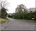
1
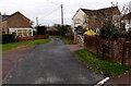
Maze Walk, Berry Hill
A secondary meaning of maze applies here - (a structure with a) single winding path much greater in distance from beginning to end than the direct line. The direct distance between the two ends of Maze Walk is 150 metres. The route ahead, from Park Road along Maze Walk to Coopers Road, is 310 metres.
Image: © Jaggery
Taken: 23 Nov 2014
0.06 miles
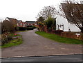
2
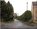
Beaumont Lane, Berry Hill
Hedged Beaumont Lane heads north away from Park Road towards The Lonk.
Image: © Jaggery
Taken: 23 Nov 2014
0.09 miles
3
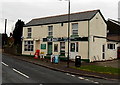
The Dairy, Berry Hill
Off licence and shop selling groceries, newspapers etc at 79 Park Road, on the corner of Tudor Walk.
Image: © Jaggery
Taken: 23 Nov 2014
0.11 miles
4
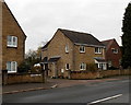
Conway Court, Berry Hill
Houses on the north side of Park Road.
Image: © Jaggery
Taken: 23 Nov 2014
0.12 miles
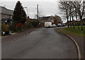
5
The Lonk towards Christchurch from Joyford Hill
Looking west across Joyford Hill. Partly hidden in the hedge on the right, the street name sign shows The Lonk. Lonk is not a standard English word - perhaps Gloucestershire dialect?
Image: © Jaggery
Taken: 23 Nov 2014
0.12 miles
6
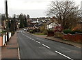
SE along Park Road, Berry Hill
Park Road is a main road running NW-SE through Berry Hill, a Gloucestershire village north of Coleford.
Image: © Jaggery
Taken: 23 Nov 2014
0.13 miles
7
Tudor Walk, Berry Hill
On the south side of Park Road.
Image: © Jaggery
Taken: 23 Nov 2014
0.13 miles
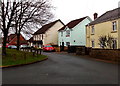
8
Hillview Rise in Berry Hill
Cul-de-sac on the south side of Park Road.
Image: © Jaggery
Taken: 23 Nov 2014
0.13 miles
9
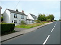
Cottage on Park Road, Berry Hill
A typical Forest of Dean cottage.
Image: © Jonathan Billinger
Taken: 6 Aug 2009
0.13 miles
10
Tudor Walk houses in Berry Hill
On the east side of a large grass triangle. http://www.geograph.org.uk/photo/4292109
Image: © Jaggery
Taken: 23 Nov 2014
0.13 miles