IMAGES TAKEN NEAR TO
St. Ann Way, GLOUCESTER, GL1 5SF
Introduction
This page details the photographs taken nearby to St. Ann Way, GL1 5SF by members of the Geograph project.
The Geograph project started in 2005 with the aim of publishing, organising and preserving representative images for every square kilometre of Great Britain, Ireland and the Isle of Man.

There are currently over 7.5m images from over14,400 individuals and you can help contribute to the project by visiting https://www.geograph.org.uk
Image Map
Images are licensed for reuse under creativecommons.org/licenses/by-sa/2.0
Notes
- Clicking on the map will re-center to the selected point.
- The higher the marker number, the further away the image location is from the centre of the postcode.
Image Listing (230 Images Found)
Images are licensed for reuse under creativecommons.org/licenses/by-sa/2.0
Image
Details
Distance
2
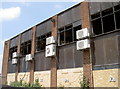
No need for air conditioning now
A former office building in St Ann Way has evidently become a victim of a fire.
Image: © Neil Owen
Taken: 19 Jun 2013
0.07 miles
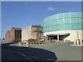
3
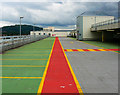
Gloucester Quays car park, High Orchard Street, Gloucester
The deserted level 3 car park still has relatively pristine lane markings. The latest aerial photos which date from 2007 don't show this new development. The high ground in the distance appears to be Haresfield Hill about 8.7 kilometres south.
Image: © Brian Robert Marshall
Taken: 6 Aug 2010
0.07 miles
4
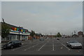
Site of Gloucester Carriage & Wagon Works
They used to build railway rolling stock here. The company were a big local employer, and in common with many similar companies, had a company brass band. I can't imagie that Toys 'R' Us features a company band. The only other notable thing about this picture is the amount of litter people think it acceptable to leave lying around. The whole car park was strewn with Burger King wrappers.
Image: © John Winder
Taken: 13 Sep 2014
0.07 miles
5
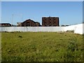
Space for development, St Ann Way, Gloucester
Open space, which was fenced in, between the shopping centre and the dock area
Image: © David Smith
Taken: 25 Nov 2016
0.07 miles
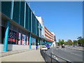
7
Gloucester Quays, outlet shopping
Stores on Bristol Road; the nearest is M&S.
Image: © Mike Faherty
Taken: 13 Oct 2018
0.08 miles
9
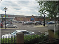
Gloucester Quays shopping outlets
Website: http://www.gloucesterquays.co.uk/
Image: © Paul Gillett
Taken: 7 May 2013
0.08 miles
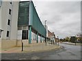
10
Entrance to car parks, Gloucester Quays shopping centre
Image: © David Smith
Taken: 25 Nov 2016
0.08 miles