IMAGES TAKEN NEAR TO
Stroud Road, GLOUCESTER, GL1 5LG
Introduction
This page details the photographs taken nearby to Stroud Road, GL1 5LG by members of the Geograph project.
The Geograph project started in 2005 with the aim of publishing, organising and preserving representative images for every square kilometre of Great Britain, Ireland and the Isle of Man.

There are currently over 7.5m images from over14,400 individuals and you can help contribute to the project by visiting https://www.geograph.org.uk
Image Map
Images are licensed for reuse under creativecommons.org/licenses/by-sa/2.0
Notes
- Clicking on the map will re-center to the selected point.
- The higher the marker number, the further away the image location is from the centre of the postcode.
Image Listing (20 Images Found)
Images are licensed for reuse under creativecommons.org/licenses/by-sa/2.0
Image
Details
Distance
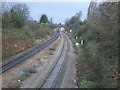
1
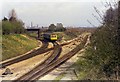
Tuffley Junction
A DMU from Gloucester Eastgate approaches Tuffley Junction on the former Midland Railway line. This line was plagued with level crossings and was eventually closed and lifted in the 1970s when all traffic was diverted into Gloucester Central. The line on the right, today's main line, is the former Great Western Main line from Gloucester South Junction. The course of line can be seen on the OS maps by examining the fence lines behind the buildings on Stroud Road.
Image: © David Stowell
Taken: Unknown
0.05 miles
2
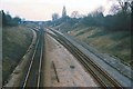
Tuffley Junction
Image shortly after closure of the ex-Midland Route into Gloucester as seen from the rusting rails on the route to the left. See Image for a view of the same place 30 years later.
Image: © David Stowell
Taken: Unknown
0.05 miles
3
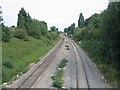
Site of Tuffley Junction
From almost the same spot as Image but some 30 years later, and little sign of remains of the former Midland line at this point.
Image: © David Stowell
Taken: 18 Sep 2005
0.05 miles
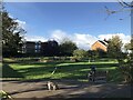
6
Tuffley Avenue, Gloucester
The house on the left is typical of many in this part of this mainly residential square. The building on the right replaced a house demolished when a 'plane crashed into it on the 27th March 1963. A twin engined Vickers Varsity aircraft crashed onto the house. The three elderly occupants survived unhurt apart from shock and scratches, however the house and the neighbouring property that the Drury family also owned were flooded with aviation fuel. The plane was on a training run from Staverton Airport and tragically the crew of two were killed. See:- http://aviation-safety.net/database/record.php?id=19630327-0 and http://www.visit-gloucestershire.co.uk/boards/topic/72-g-apaz-the-tuffley-varsity/ .
From a personal perspective I remember cycling home from school nearby and seeing the area cordonned off and the remains of the fuselage embedded in the top half of the house.
Image: © David Stowell
Taken: 18 Sep 2005
0.10 miles
7
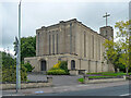
St Barnabas, Stroud Road, Gloucester
By N.F. Cachemaille-Day, 1938-40, "the best interwar church in the county". Grade II* listed.
Image: © Stephen Richards
Taken: 19 May 2015
0.12 miles
8
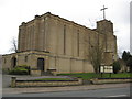
St Barnabas church
St Barnabas church was built in 1938-40 and is described by Pevsner as 'the best interwar church in the county'.
Image: © Philip Halling
Taken: 20 Mar 2010
0.12 miles
9
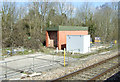
Former Tuffley Junction
The railway line once split off to the left as can be seen in another image on this gridsquare. The location is now growing birches and brambles but just beyond the photo the house of Larkspear Close have been built on the route of the old track. Viewed from the Stroud Road bridge.
Image: © David Collins
Taken: 11 Jan 2007
0.13 miles
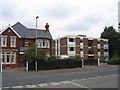
10
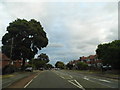
Finlay Road, Tuffley
Living in what used to be Middlesex this could be just about anywhere in Harrow or Edgware.
Image: © David Howard
Taken: 28 Jul 2018
0.14 miles