IMAGES TAKEN NEAR TO
Calton Road, GLOUCESTER, GL1 5DT
Introduction
This page details the photographs taken nearby to Calton Road, GL1 5DT by members of the Geograph project.
The Geograph project started in 2005 with the aim of publishing, organising and preserving representative images for every square kilometre of Great Britain, Ireland and the Isle of Man.

There are currently over 7.5m images from over14,400 individuals and you can help contribute to the project by visiting https://www.geograph.org.uk
Image Map
Images are licensed for reuse under creativecommons.org/licenses/by-sa/2.0
Notes
- Clicking on the map will re-center to the selected point.
- The higher the marker number, the further away the image location is from the centre of the postcode.
Image Listing (34 Images Found)
Images are licensed for reuse under creativecommons.org/licenses/by-sa/2.0
Image
Details
Distance
1
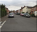
East along Linden Road, Gloucester
From the corner of Stanley Road along Linden Road towards Calton Road.
Image: © Jaggery
Taken: 6 Nov 2016
0.04 miles
2

North side of Tweenbrook Avenue, Gloucester
Viewed from the Stroud Road end.
http://www.geograph.org.uk/photo/2905450 to a view of the south side.
Image: © Jaggery
Taken: 13 Apr 2012
0.05 miles
3

South side of Tweenbrook Avenue, Gloucester
Viewed from the Stroud Road end.
http://www.geograph.org.uk/photo/2905451 to a view of the north side.
Image: © Jaggery
Taken: 13 Apr 2012
0.05 miles
4

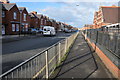
Linden Road speed bumps and bus stop, Gloucester
Linden Road between the Stanley Road junction and the Rosebery Avenue junction.
Image: © Jaggery
Taken: 6 Nov 2016
0.09 miles
5
Calton Road, Gloucester
Calton Road passing Calton Junior School in the suburbs of Gloucester.
Image: © Philip Halling
Taken: 26 Feb 2011
0.09 miles
6
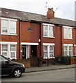
Banwell Terrace name, Stanley Road, Gloucester
This is one of several separately named rows of houses in Stanley Road.
Image: © Jaggery
Taken: 6 Nov 2016
0.10 miles
7

Calton Junior School
Calton Junior School on Calton Road, Gloucester.
Image: © Philip Halling
Taken: 26 Feb 2011
0.10 miles
8
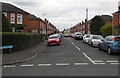
Stanley Road, Gloucester
Viewed across Linden Road. An Asda home delivery van is in the middle of the road.
Image: © Jaggery
Taken: 6 Nov 2016
0.10 miles
9

King George VI pillarbox on a Gloucester corner
On the corner of Rosebery Avenue and Linden Road.
Image: © Jaggery
Taken: 6 Nov 2016
0.10 miles
10

Ribston Hall High School
Located in the very Roman-sounding Via Ribston. This girls' school dates back to the 19th century. http://www.ribstonhall.gloucs.sch.uk/page/?title=Our+History&pid=11 The school shares this road with Ribston Mews, a gated development.
Image: © HelenK
Taken: 30 Jul 2016
0.14 miles