IMAGES TAKEN NEAR TO
Trowgreen, LYDNEY, GL15 6QP
Introduction
This page details the photographs taken nearby to Trowgreen, GL15 6QP by members of the Geograph project.
The Geograph project started in 2005 with the aim of publishing, organising and preserving representative images for every square kilometre of Great Britain, Ireland and the Isle of Man.

There are currently over 7.5m images from over14,400 individuals and you can help contribute to the project by visiting https://www.geograph.org.uk
Image Map
Images are licensed for reuse under creativecommons.org/licenses/by-sa/2.0
Notes
- Clicking on the map will re-center to the selected point.
- The higher the marker number, the further away the image location is from the centre of the postcode.
Image Listing (6 Images Found)
Images are licensed for reuse under creativecommons.org/licenses/by-sa/2.0
Image
Details
Distance
1
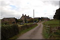
Trowgreen Farm
Trow Green lies on the B4228 near St Briavels in the Forest of Dean.
Image: © Roger Davies
Taken: 3 Oct 2009
0.02 miles
2

Former tollhouse at Trow Green
The tollhouse dates from the early 19th century
Image: © David Smith
Taken: 16 Apr 2013
0.05 miles
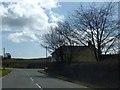
3
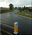
Road junction near Bream
Junction of the B4231 (Bream Avenue) with the B4228 opposite Trowgreen Farm near Bream.
Image: © Clint Mann
Taken: 25 Aug 2014
0.05 miles
4
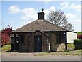
Pike House, Trow Green
A former Toll House on the B4228 South of Coleford, and 1km South of Image It served the Forest of Dean Turnpike Trust and dates from the early 19ᵗʰ c.
Grade II listed Nᴼ. 1186347 see https://historicengland.org.uk/listing/the-list/list-entry/1186347
Milestone Society National ID: GL.NEW
Image: © Mr Red
Taken: 16 May 2023
0.05 miles
5
Trowgreen Farm
A wet day as can be seen with the raindrops on lens.
Image: © Jonathan Billinger
Taken: 4 Dec 2006
0.07 miles
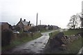
6
Cottage and road junction at Trow Green
Image: © David Smith
Taken: 16 Apr 2013
0.14 miles