IMAGES TAKEN NEAR TO
Main Road, LYDNEY, GL15 6BE
Introduction
This page details the photographs taken nearby to Main Road, GL15 6BE by members of the Geograph project.
The Geograph project started in 2005 with the aim of publishing, organising and preserving representative images for every square kilometre of Great Britain, Ireland and the Isle of Man.

There are currently over 7.5m images from over14,400 individuals and you can help contribute to the project by visiting https://www.geograph.org.uk
Image Map
Images are licensed for reuse under creativecommons.org/licenses/by-sa/2.0
Notes
- Clicking on the map will re-center to the selected point.
- The higher the marker number, the further away the image location is from the centre of the postcode.
Image Listing (89 Images Found)
Images are licensed for reuse under creativecommons.org/licenses/by-sa/2.0
Image
Details
Distance
1
NE boundary of Alvington
The A48 from Lydney via Aylburton reaches Alvington, a small village in Gloucestershire. Alvington was part of Herefordshire in the late 11th century, but had become part of Gloucestershire by the early 13th century. A document dated 1327 records the population as 41. That small figure is very likely to have been greatly reduced by the Black Death two decades later. The current population is about 500.
Image: © Jaggery
Taken: 1 Jan 2013
0.02 miles
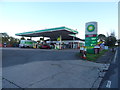
2
BP filling station on edge of Alvington
Image: © David Smith
Taken: 24 Jul 2013
0.04 miles
3
BP filling station, Alvington
On the A48
Image: © David Smith
Taken: 3 Aug 2018
0.04 miles
5
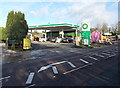
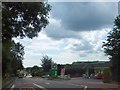
Filling station, shop and car wash, Alvington
Located alongside Main Road (the A48) in the NE of the village. The BP filling station was formerly a Texaco filling station. The Londis shop was formerly a Mace shop. At the back of the site is Alvington Hand Car Wash.
Image: © Jaggery
Taken: 1 Jan 2013
0.04 miles
6
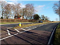
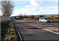
SW end of a short dual carriageway, Alvington
Near the NE edge of the village, a thin strip of grass marks a carriageway divider.
The strip extends for less than 200 metres along the middle of the A48.
Image: © Jaggery
Taken: 1 Jan 2013
0.05 miles
7
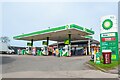
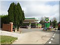
Alvington : BP Petrol Station
A BP petrol station off the A48.
Image: © Lewis Clarke
Taken: 22 Mar 2023
0.05 miles
8
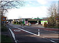
30mph and speed camera signs at the NE edge of Alvington
The National Speed Limit along the A48 reduces to 30mph through Alvington.
On the right are a filling station, shop and hand car wash. http://www.geograph.org.uk/photo/3279135
Image: © Jaggery
Taken: 1 Jan 2013
0.05 miles
9
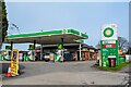
Alvington : BP Petrol Station
A BP petrol station off the A48.
Image: © Lewis Clarke
Taken: 22 Mar 2023
0.05 miles
10
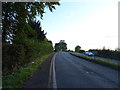
The A48 near Alvington
Towards Gloucester.
Image: © JThomas
Taken: 17 Oct 2019
0.06 miles