IMAGES TAKEN NEAR TO
The Orchards, LYDNEY, GL15 5JR
Introduction
This page details the photographs taken nearby to The Orchards, GL15 5JR by members of the Geograph project.
The Geograph project started in 2005 with the aim of publishing, organising and preserving representative images for every square kilometre of Great Britain, Ireland and the Isle of Man.

There are currently over 7.5m images from over14,400 individuals and you can help contribute to the project by visiting https://www.geograph.org.uk
Image Map
Images are licensed for reuse under creativecommons.org/licenses/by-sa/2.0
Notes
- Clicking on the map will re-center to the selected point.
- The higher the marker number, the further away the image location is from the centre of the postcode.
Image Listing (547 Images Found)
Images are licensed for reuse under creativecommons.org/licenses/by-sa/2.0
Image
Details
Distance
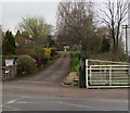
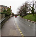
1
The Orchards, Lydney
Dead-end road extending northeastwards for 130 metres from the B4231 Bream Road.
Goode Court http://www.geograph.org.uk/photo/4963840 is on the left. Bream Road car park http://www.geograph.org.uk/photo/4963847 is on the right.
Image: © Jaggery
Taken: 22 May 2016
0.02 miles
2

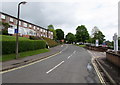
Goode Court, Lydney
Managed by Housing & Care 21, Goode Court is retirement/sheltered housing
containing 30 flats, built in 1979, renovated in 2001. Viewed across Bream Road.
Image: © Jaggery
Taken: 22 May 2016
0.04 miles
3
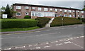
Goode Court, Lydney
The Orchards side of Goode Court, on the corner of Bream Road. Managed by Housing & Care 21,
Goode Court is retirement/sheltered housing containing 30 flats. Built in 1979, renovated in 2001.
Image: © Jaggery
Taken: 22 May 2016
0.04 miles
4
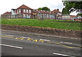
Lydney Church of England Primary School
Viewed across Bream Road in Lydney.
Image: © Jaggery
Taken: 22 May 2016
0.05 miles
5
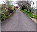
Hill View, Lydney
Cul-de-sac above Hill Street.
Image: © Jaggery
Taken: 15 Apr 2018
0.05 miles
6
Hill View, Lydney
Cul-de-sac viewed across Hill Street. A Dean Forest Railway level crossing gate is on the right.
Image: © Jaggery
Taken: 15 Apr 2018
0.05 miles
7
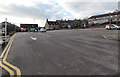
Bream Road car park, Lydney
Located behind the library http://www.geograph.org.uk/photo/3291873 and shops in Cavendish Buildings.
Image: © Jaggery
Taken: 1 Jan 2013
0.05 miles
8
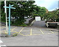
Bench with a view of a Lydney car park
The bench is at the eastern edge of Bream Road pay & display car park. http://www.geograph.org.uk/photo/4963847
The signpost shows supermarket 270 metres to the left,
shops 230 metres to the right and library behind the camera.
Image: © Jaggery
Taken: 22 May 2016
0.06 miles
9
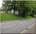
Directions sign, Bream Road, Lydney
Facing the B4231 Bream Road. At the bottom of the hill, turn left for Gloucester, right for Chepstow.
Image: © Jaggery
Taken: 22 May 2016
0.06 miles
10
Up Bream Road, Lydney
The B4231 Bream Road ascends from the corner of Stanford Road.
A sign https://www.geograph.org.uk/photo/4963916 near the camera shows Coleford 7 (miles), Monmouth 12.
Image: © Jaggery
Taken: 5 Jan 2020
0.06 miles