IMAGES TAKEN NEAR TO
Stanford Road, LYDNEY, GL15 5HR
Introduction
This page details the photographs taken nearby to Stanford Road, GL15 5HR by members of the Geograph project.
The Geograph project started in 2005 with the aim of publishing, organising and preserving representative images for every square kilometre of Great Britain, Ireland and the Isle of Man.

There are currently over 7.5m images from over14,400 individuals and you can help contribute to the project by visiting https://www.geograph.org.uk
Image Map
Images are licensed for reuse under creativecommons.org/licenses/by-sa/2.0
Notes
- Clicking on the map will re-center to the selected point.
- The higher the marker number, the further away the image location is from the centre of the postcode.
Image Listing (567 Images Found)
Images are licensed for reuse under creativecommons.org/licenses/by-sa/2.0
Image
Details
Distance
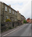
1
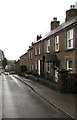
Stanford Road stone houses, Lydney
Alongside the descent to Bream Road.
Image: © Jaggery
Taken: 5 Jan 2020
0.00 miles
2
Stanford Road houses, Lydney
Viewed from the edge of Bream Road car park.
Image: © Jaggery
Taken: 22 May 2016
0.01 miles
3
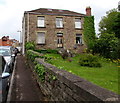
The Point, Lydney
The Point is a house occupying a triangular site between Stanford Road on the left and Bream Road.
The garden tapers towards the point near the junction of the two roads.
Image: © Jaggery
Taken: 22 May 2016
0.01 miles
4
Junction of Stanford Road and Grove Road, Lydney
Viewed from Stanford Road.
Image: © Jaggery
Taken: 5 Jan 2020
0.02 miles
5
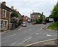
Junctions in Lydney
The main road is the B4231 Bream Road. Stanford Road leading to Grove Road is on the left.
The right turn is into the dead-end road The Orchards http://www.geograph.org.uk/photo/4963869 and the entrance to Bream Road car park.
Image: © Jaggery
Taken: 22 May 2016
0.02 miles
6
Three-way junction in Lydney
The main road is the B4231 Bream Road.
The Orchards junction is on the right.
The Stanford Road junction is on the left.
Image: © Jaggery
Taken: 2 May 2021
0.03 miles
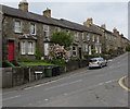
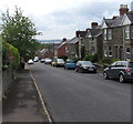
7
Stone houses, Stanford Road, Lydney
Looking towards a brick house on the corner of Grove Road.
Image: © Jaggery
Taken: 22 May 2016
0.03 miles
8
Down Grove Road, Lydney
Grove Road descends towards the Stanford Road junction.
Image: © Jaggery
Taken: 22 May 2016
0.03 miles
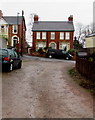
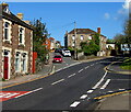
9
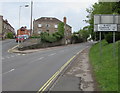
B4231 distances from Lydney
The sign faces the B4231 Bream Road at the Stanford Road junction, 12 (miles) from Monmouth, 7 from Coleford.
Image: © Jaggery
Taken: 22 May 2016
0.03 miles
10

Directions sign near the bottom of the B4231 Bream Road, Lydney
Opposite the Stanford Road junction, the sign shows turn left (into Hill Street about 90 metres ahead) for the bus station, recreation ground and the Dean Forest Steam Railway. Turn right (into High Street) for Lydney mainline railway station and an industrial estate. The left turn nearest the sign leads to a car park.
Image: © Jaggery
Taken: 22 May 2016
0.03 miles