1
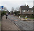
Church Road traffic calming, Lydney
Vehicles on the camera side have priority through the narrow part of Church Road alongside the sign.
The top of the spire https://www.geograph.org.uk/photo/1944206 of St Mary's Church is in the background.
Image: © Jaggery
Taken: 15 Apr 2018
0.02 miles
2
Church Road, Lydney
This road links the town centre with the parish church and main line railway station to the south of the town.
Note the fine yew tree to the left.
Image: © Jonathan Billinger
Taken: 17 Mar 2008
0.03 miles
3
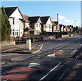
Church Road houses, Lydney
A view SE from near the Whitecross Road junction.
Image: © Jaggery
Taken: 1 Jan 2013
0.03 miles
4
Lydney Bowling Club
The lawn bowls club building is in Bathurst Park, to the south of the park's bowling green. Viewed from a footpath named Avenue Andre Clement.
Image: © Jaggery
Taken: 8 Feb 2013
0.03 miles
5
Keep Clear Zone, Church Road, Lydney
At the entrance to the Dean Academy (formerly Whitecross School) and
Freedom Leisure Lydney (formerly Whitecross Leisure Centre).
Image: © Jaggery
Taken: 15 Apr 2018
0.03 miles
6
Entrance to Bathurst Park, Lydney
The entrance is at the SW corner of the park. The Bathurst family were major landowners and benefactors in Lydney.
Image: © Jaggery
Taken: 26 Jun 2010
0.04 miles
7
Brehal Close, Lydney
Cul-de-sac viewed across Church Road. Lydney is twinned with Bréhal, a commune in Normandy, France.
Image: © Jaggery
Taken: 15 Apr 2018
0.04 miles
8
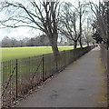
Path between railings, Bathurst Park, Lydney
The footpath is named Avenue Andre Clement.
The main part of Bathurst Park is on the left side of the railings.
There are various sports areas on the right side of the railings.
Image: © Jaggery
Taken: 8 Feb 2013
0.05 miles
9
Southern end of Avenue Andre Clement, Lydney
Avenue Andre Clement is a footpath through Bathurst Park.
Ahead, the path passes under these http://www.geograph.org.uk/photo/1944223 former almshouse.
St Mary's church steeple http://www.geograph.org.uk/photo/3325837 is in the background.
Image: © Jaggery
Taken: 8 Feb 2013
0.06 miles
10
Mural in Lydney
The murals cover the entire walls, including the roof, of the passage through the former almshouses on Church Road, going to Bathurst Park.
Image: © Eirian Evans
Taken: 13 Feb 2018
0.06 miles


